|

We already have seen the cube and octahedron in the Earth from Cathie, and
the tetrahedron across the Solar System from Hoagland. That only leaves us
with the task of locating Purusha and Prakriti, the
icosahedron and
dodecahedron, in order for our Global Grid to be complete. It is
William
Becker and Bethe Hagens who ultimately solved the puzzle for us. At the time
their work was published, Dr. Becker was a Professor of Industrial Design at
the University of Illinois, Chicago, and Dr. Hagens was a Professor of
Anthropology at Governors State University. Together, they demonstrated how
these two shapes were first discovered, and then how they assimilated into
the ultimate Earth Grid, which they called the Unified Vector Geometry 120
Polyhedron, or the UVG 120 "Earth Star."
Although we had said before that the modern history of the Global Grid may
start with Bruce Cathie, the former husband-and-wife team of Becker and
Hagens have a different idea. They ascribe this discovery to the work of
Ivan P. Sanderson, who was the first to make a case for the structure of the
icosahedron at work in the Earth. He did this by locating what he referred
to as "vile vortices," or areas of the Earth where mysterious
disappearances, mechanical failures and time-space distortions were seen to
occur. Obviously, most readers are aware that the
Bermuda Triangle reports
from the east coast of Florida would fall into this category, but Sanderson
looked at other, less popular areas as well. These areas were often referred
to as "Devilís Graveyards," since many explorers simply disappeared if they
crossed over them at the wrong time of year, apparently with the wrong lunar
and planetary alignments activating that particular area.
What initially led Sanderson to this work is the case of, as Charles Hapgood
referred to them, The Maps of the Ancient Sea Kings. We now know that during
the time of
Atlantis and perhaps much earlier, the entire Earthís
coordinates had been mapped out by the construction of the different
pyramids, temples and earthworks on the Earthís surface. Carl Munck
demonstrates this beyond all possible doubt. Therefore, it is almost
inevitably obvious that there must have been many Atlantean maps of the
world at one time. These maps would have been very precise, given the level
of sophistication that we have seen in the precise execution of Munckís
worldwide "Code" of coordinates.
We can speculate on how these maps might have been handed down, based on a
variety of sources of information. We are told that after the last pole
shift 12,500 years ago, the main body of Atlantean land sank. The survivors
from the Atlantean priesthood kept themselves in a tight-knit, secluded
monastic community, since most of the rest of humanity had descended into
barbarism. Since most of the land disappeared, with only a few survivors
left, it is clear that only a select few of these maps remained as well.
The Sumerian civilization may have been the Atlanteansí first attempt to
rebuild society to any significant degree, and this was started circa 6,000
BC- roughly 8,000 years ago. As
Zecharia Sitchin and others have pointed
out, the Sumerian civilization certainly seemed to spring up quite
spontaneously and dramatically. In a very short amount of time, they had
written language, education, laws, agriculture and running water, for
example. We know that the Sumerians had the Constant of Nineveh, the cycle
we discussed earlier.
Then, when we factor in Dr. Zecharia Sitchinís deeper work as well, we
realize that a group that had access to incredible technology aided the
Sumerians, a group that possessed flying machines, lasers and other exotic
equipment. A very advanced understanding of science and physics was present
as well, including the knowledge of the full spectrum of planets in the
Solar System. We are also told in the ancient Hindu Vedas and the
Cayce
Readings that Atlanteans did indeed possess flying machines, so this checks
out. (It also could be that the Atlanteans were cooperating with Space
Brothers that they had interacted with as well, given the preponderance of
"Ancient Astronaut" data that is available.
Sitchinís data very strongly
suggests the existence of
the Annunaki, or "Those who from Heaven to Earth
Came.")
The maps were kept within the high ranks of the priesthood well after the
start of the Sumerian civilization, and eventually, they were secreted into
the Library of Alexandria in Egypt, and later into the academic halls of
Greece. It is believed that only those who were members of the secret
brotherhoods knew of the existence of these maps. The argument for the
secret brotherhoodsí existence is extremely strong, and the best book Wilcock has ever found on this topic is
The People of the Secret by Ernest
Scott, Octagon Press, London 1983. Scottís work leaves no doubt whatsoever
that this Brotherhood existed, that it secretly allied the major religions
of Christianity, Islam and Judaism, and that it still persists in the
present moment as a positive group that communes with Higher Intelligence
and seeks to gradually unveil the Mysteries to our civilization.
So, these secret brotherhoods sent out seafaring explorers to rediscover the
lands that were hidden on their maps, to eventually rebuild a great,
technological civilization like Atlantis. Francis Bacon, the father of
modern Freemasonry, declared the American continent to be the site for the
"New Atlantis." And, in order to set this plan into action, the explorers
themselves would need to copy over the maps, at least in part, so that they
would have something they could work with. Certain authors including Hancock
in Fingerprints of the Gods speculate that Columbus had access to these
maps, and therefore knew that the Earth was actually round, and that new
lands would be found overseas.
All of this proved to be quite interesting to Ivan P. Sanderson, the "father
of the Grid," and now we will see why. The first explorer that we are aware
of who copied over one of these maps is
Admiral Piri Reis, in 1513 AD. This
map focuses on Africaís west coast, South Americaís east coast and the
northern coast of Antarctica. What is so interesting is that it shows the
Antarctic Queen Maud Land area as an ice-free coast. And, as Hancock writes
in Fingerprints, in order for this coast to have been surveyed without ice,
it would have to have been mapped between 13,000 and 4,000 BC! Modern
humanity did not know the outline of this coast until 1949, as a result of a
comprehensive seismic survey by a joint British-Swedish reconnaissance team.
(Hancock 1995, pg. 12.)
The man who put all of this map information together is Charles Hapgood,
however his theories did not initially start with these maps. Hapgood was a
History of Science professor at Keene College in New Hampshire, although his
areas of inquiry obviously went far beyond simple history. Hapgoodís basic
theory concerns Earth crustal displacement, a close analog to the idea of
"pole shift," where the surface of the Earth actually changes position.
Hapgood says that the entire surface crust of the Earth "may be displaced at
times, moving over the soft inner body, much as the skin of an orange, if it
were loose, might shift over the inner part of the orange all in one piece."
This theory drew the attention of Albert Einstein as well, who contributed
the forward to Hapgoodís 1953 book. Einsteinís quote, reprinted on pg. 10 of
Hancockís book, is definitely worth inserting here:
I frequently receive communications from people who wish to consult me
concerning their unpublished ideas [Einstein observed]. It goes without
saying that these ideas are very seldom possessed of scientific validity.
The very first communication, however, that I received from Mr. Hapgood
electrified me. His idea is original, of great simplicity, and - if it
continues to prove itself - of great importance to everything that is
related to the history of the earthís surface.
Einstein also expressed his own ideas as to how this earth movement might
occur:
In a polar region there is continual deposition of ice, which is not
symmetrically distributed about the pole. The earthís rotation acts on these
unsymmetrically deposited masses, and produces centrifugal momentum that is
transmitted to the rigid crust of the earth. The constantly increasing
centrifugal momentum produced in this way will, when it has reached a
certain point, produce a movement of the earthís crust over the rest of the
earthís bodyÖí
And so, Hapgoodís theory explained that at various points in time, the
landmass of Antarctica would move out of the coldest regions, by
Earth Crustal Displacement. And, he certainly wins "brownie points," since the
best scientist who ever lived substantiated his theory. In later chapters we
will see that these facts harmonize with the information from
Gregg Braden
regarding the rise in the Earthís "heartbeat" and decrease in its magnetic
field strength. Braden reveals that these phenomena have always occurred
directly before cases of magnetic pole shift in the past, which could well
be "Earth Crustal Displacement" in action.
We can see that if Hapgoodís theory is correct, the Atlantean inundation was
the most recent example of this displacement, as prior to this point, many
maps were drawn of Antarctica without ice. Therefore, the shifting Earthís
crust must have positioned Antarctica in a warmer area before the most
recent displacement. So, Hapgoodís model is the best conception that we have
for why Antarctica would be in a warmer region. Along with Fingerprints of
the Gods, the book When the Sky Fell by Rand and Rose Flem-Ath is also an
excellent source for further scientific detail on these points.
The other maps that also showed Antarctica under the ice included the
Oronteus Finaeus map of 1531. In this case, we get a complete view of
Antarctica, with the edges largely uncovered by ice. Rivers and mountains
are clearly visible. Another very similar map was produced by Gerard Kremer,
known to the world as Mercator, the author of the modern Mercator map
projection that is now so commonly used. Hapgood concludes that
Mercator had
access to other source maps besides those used by Oronteus Finaeus, since
many recognizable features of Antarctica are more clearly visible in his
work. So, it appears that there were definitely several copies available
during those times.
 Another mapmaker who demonstrated equal sourcing and knowledge was
Phillippe
Buache (right image), a French geographer of the eighteenth century. His 1737 map on
right, shows us
a version of Antarctica that apparently has no ice on it at all! As we can
see, there is a clear waterway that runs straight through the middle,
dividing the continent into two main landmasses, one large and one smaller,
perhaps a fifth the size of the larger. Another mapmaker who demonstrated equal sourcing and knowledge was
Phillippe
Buache (right image), a French geographer of the eighteenth century. His 1737 map on
right, shows us
a version of Antarctica that apparently has no ice on it at all! As we can
see, there is a clear waterway that runs straight through the middle,
dividing the continent into two main landmasses, one large and one smaller,
perhaps a fifth the size of the larger.
What makes this even more amazing is that the Buache version of Antarctica
is nearly identical to what we actually discovered in 1958, as a part of
International Geophysical Year. In this case, a comprehensive seismic survey
of the "subglacial topography" of Antarctica was conducted. And indeed, the
separation between the landmasses, shown in the Buache map as a waterway, is
in almost exactly the same place. Both the smaller and larger landmass in
the Buache map are very closely approximated by the findings of the
scientists in 1958.
So obviously, this is a highly interesting phenomenon, and it goes hand in
hand with the work of Carl Munck. Hapgoodís work, which again caught the
academic interest of Einstein, provides the foundation for understanding why
the Ancients would have known the global coordinates as exactly as they did.
We now come back to Ivan P. Sanderson, who also studied Hapgoodís work and
was mystified by these incredible pieces of evidence. Sanderson sought to
figure out how these ancient mapmakers were able to plan out a full, global
map. What type of models would they need to have in order to do something
like this, and use it? How did they divide the Earthís surface up into
measurable units? And furthermore, was there anything that was physically
observable and measurable in the vastness of Earthís oceans, so that these
mapmakers would actually know where they were in the middle of the sea?
Sanderson worked on this puzzle with several associates throughout the 60s
and into the 70s. He tackled huge volumes of data, mostly from anomalous
reports declared by hundreds of pilots and mariners, and systematically
organized them. His results proved beyond a shadow of a doubt that some very
interesting anomalies were visible in certain areas of the Earthís oceans.
These anomalies are all very familiar to us, as being those commonly
reported in the Bermuda Triangle. This was certainly one vortex that
interested Sanderson immensely, although there were other areas that were
much more neglected as well.
Using statistical analysis to crunch all the data together, concerning all
the different places where these events occurred on the globe, Sanderson
was
able to derive twelve common points of anomalous occurrence on the Earth.
Amazingly, these twelve points were all equally, harmonically spaced from
each other! The effects of these "vile vortices," as he called them,
included not only disappearances but apparently time-warping events as well.
Many of these were recorded in books such as Charles Berlitzís The Bermuda
Triangle, but Sanderson found evidence for these time-space disturbances in
the other vortices as well, not just by Bermuda.
For example, one of Sandersonís vortices was located near Hawaii. He found a
report of a pilot, flying with passengers very near this zone, who suddenly
lost all of his instruments as well as radio communications. This is called
a "dead zone," or "flying blind," with no ability to radio for help or to
determine altitude, position, et cetera, except by "eyeballing" it. The
pilot continued to fly for roughly 350 miles in this "dead zone," without
being able to connect with anyone on the radio; anywhere from 30 minutes to
an hour, depending on his speed. Finally, the bizarre experience came to an
end, and he was very relieved to be able to get in touch with the tower yet
again. We can imagine the panic and astonishment that must have been in his
voice, narrowly avoiding danger and wondering what the heck had just
happened.
What was so amazing and unexpected was that according to the tower
officials, no time had elapsed between his radio contacts! In other words,
at one moment he was speaking to them normally, and ten seconds later he was
in a panic, telling them that he had flown 350 miles without any
instruments! As amazing as it must seem to our "common sense," all
passengers aboard this aircraft must have passed into a higher dimensional
frequency, where they were not affected by time. The cause of this effect
was the hyperdimensional energy that was harnessed by the "vile vortex" they
were flying through.
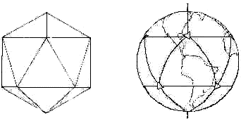
By now, the reader should not be surprised when we restate that Sandersonís
twelve symmetrically spaced vortices do indeed graph out one of the Platonic
Solids, namely the icosahedron. This is indicated in the following
illustration from Nicholas R. Nelsonís book Paradox (Dorrance & Co.,
Ardmore, Penn. 1980,) reprinted in David Hatcher Childressí book,
Anti-Gravity and the World Grid (We digitally altered the image to
preserve its simplicity in this small format.)
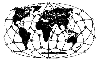
Sandersonís popular work certainly ignited a firestorm of interest
worldwide. The problem was quickly picked up and tackled by a group of three
Russian scientists: Nikolai Goncharov, a Muscovite historian, Vyacheslav
Morozov, a construction engineer and Valery Makarov, an electronics
specialist. These three scientists worked directly off of Sandersonís
research, and the twelve points of the icosahedron were placed in almost the
exact same location. But, these scientists also added 50 more points, by
superimposing a dodecahedron onto
the Grid as well. Their results produced
the following map, first printed in the popular Soviet science journal Khimiyai Zhizn, (or Chemistry and Life,) reproduced in
Anti-Gravity and the
World Grid:
These three scientists worked off of their combined talents to determine
this "matrix of cosmic energy" that encircles the Earth. With this new
formulation of the Global Grid, Becker and Hagens write:
These new lines and points, in conjunction with
Sandersonís, now matched
most of the earthís seismic fracture zones and ocean ridge lines as well as
outlined worldwide atmospheric highs and lows, paths of migratory animals,
gravitational anomalies, and even the sites of ancient cities.
Becker and Hagensí attention was drawn to this research through the work of
Chris Bird, who wrote his article on the "Planetary Grid" in the New Age
Journal of May 1975. They were so overwhelmed with this new information that
they eventually set up a meeting with him to discuss the work. Soon after
this, they "completed" the Grid, making it compatible with all the
Platonic
Solids, by inserting a creation from Buckminster Fullerís work. In the
following quote, they explain in precise terms exactly what they did:
We propose that the planetary grid map outlined by the Russian team
Goncharov, Morozov and Makarov is essentially correct, with its overall
organization anchored to the north and south axial poles and the Great
Pyramid at Gizeh. The Russian map, however, lacks completeness, in our
opinion, which can be accomplished by the overlaying of a complex,
icosahedrally-derived, spherical polyhedron developed by R. Buckminster
Fuller. In his book Synergetics 2, he called it the "Composite of Primary
and Secondary Icosahedron Great Circle Sets." We have shortened that to
Unified Vector Geometry (UVG) 120 sphere… We use the number 120 due to its
easy comprehension as a spherical polyhedron with 120 identical triangles -
all approximately 30, 60 and 90 in composition.
And now, the moment weíve all been waiting for: the
Becker / Hagens grid,
which finally "cracked the code" of the Platonic Solidsí positions on Earth.
Right away, you should be able to see the amazing correspondences of this
Grid to the physical forms of the continents, among other things.
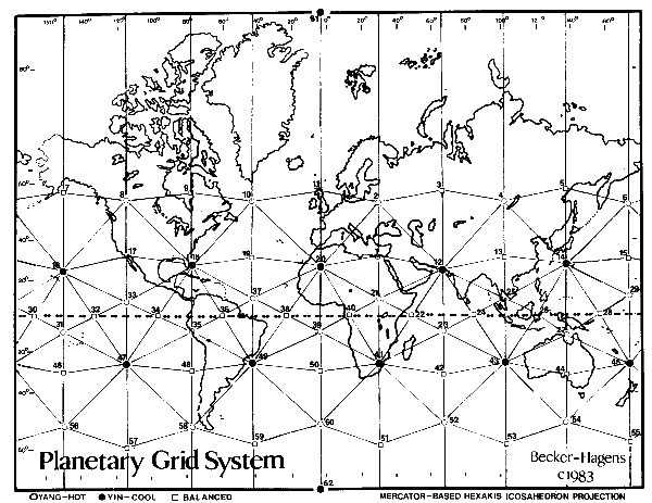
"click" image to enlarge
The following credits need to be given when reprinting this photo:
The Planetary Grid System shown [here] was inspired by an original article
by Christopher Bird, "Planetary Grid," published in New Age Journal #5, May
1975, pp. 36-41. The hexakis icosahedron grid, coordinate calculations, and
point classification system are the original research of Bethe Hagens and
William S. Becker. These materials are distributed with permission of the
authors by Conservative Technology Intl. in cooperation with Governors State
University, Division of Intercultural Studies, University Park, Illinois
60466 312/534-5000 x2455. This map may be reproduced if they are distributed
without charge and if acknowledgement is given to Governors State University
(address included) and Mr. Bird.
It becomes immediately obvious that this Grid indeed controls the
positioning of continental landmass on the Earth. Our favorite examples,
both of which combine "nodes" and force lines, are South America and
Australia. In the picture to follow on the next page, we can clearly see the
detail that reveals the precision of the structuring of Earth that is
occurring from this interplay of Grid forces:
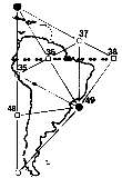
So, it should be visible to "those with eyes to see" that
the Global Grid is
very obviously shaping these land structures. If you look at South America,
for example, you can see the extremely obvious effect of this particular
"grid triangle," in literally forming the continent around itself. In
looking at the southernmost tip of South America, you can see how the force
of node number 58 pushes the land away from its due south trend and towards
the east. Then, if you look at node 49, on the middle of the East Coast of
South America near Rio de Janeiro, you can clearly see how the force of the
node has pushed the landmass of the continent into a rounded shape.
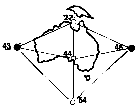
Then, looking at Australia, you can clearly see that the whole continent,
and especially the northwest side, forms very precisely within the
stretching forces of this area of the Global Grid. Here, if we look to the
exact north and middle of Australia on point 27, we see a circular "node
point" displacing the land around it and forming the Gulf of Carpenteria.
Again, the nodes themselves have shaped the land into circular "vortices,"
repelling the continental mass from themselves and in this case, also
shaping the outline of the island directly above Australia. These circular
forms, as we shall continue to see, are consistently visible in conjunction
with the Global Grid. We saw them in Egypt on our chapter regarding
Carl Munck, forming the Nile River coastline on the Mediterranean.
Also, node 44 is precisely aligned with the bottom of Antarctica, and we see
either edge "drooping" to the right or the left from this. According to
Richard Lefors Clark, this is the "bowtie"
energetic configuration showing
itself in the Australian landmass, which he calls a "diamagnetic energy
vortex." We will examine how such a shape could be formed by the curved,
spiraling energies that make up the grid below. Clark also shows us that the
Gulf of Mexico follows this same curving energetic organization, as well as
the two coastlines of the continental United States.
Next, look at Africa, and see the combined action of two larger triangles,
one with the point facing downwards on the African continent and its
neighbor pointing upwards, girding the Indian Sea:
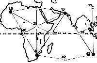
The downward-pointing triangle certainly describes Africa well, and the
extra land on the western side can be explained by the pressure coming from
the Mid-Atlantic Ridge, which is almost precisely the same as the Atlantic
grid line formed by points 10, 19, 37, 38, 39 and 50. The east coast of
Africa and Saudi Arabia follow the eastern side of the triangle very nicely,
on the grid line from point 41 to point 12.
We can also see how node point 22 gently pushes in on Africaís east coast,
causing it to dip inwards as it travels and forming the Somalia Basin. We
can also assume that the "cracks" separating Africa and Saudi Arabia were
caused by the expansion of the Grid, forcefully pulling the land into
alignment. The "crack" to the immediate left of point 12 follows the grid
line exactly. And finally, the upward-pointing triangle can be clearly seen
to cut its way right into the land, with Africaís coast defining its left
side and Indiaís coast defining its right.
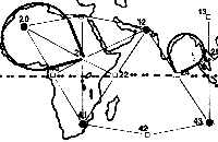
In this next illustration above, we can see how point 21, in the center of
the African continent, works with its above-right partner point 20 in
providing a framework for the bow-shaped energy vortex that shaped the
northeast coast of Africa. Point 20 is the only "vile vortex" that is
significantly inland; 41, near South Africa, and 42, near India, are the
only others that touch land at all! This is probably due to the incredible
strength that they possess, which seems to repel landmasses. We can see how
the northeast coast of Africa is indeed very circular, and point 20 is
directly at the center of this "bowtie" of energy.
Again, we see Dr. Lefors Clarkís bow-shaped "diamagnetic energy vortex"
shaping the land in a smooth curve. We can also see the same curving
formation created by the east coast of India and the west coast of the China
/ Korea / Vietnam area of Asia. This vortex is balanced between points 24
and 13. We remind ourselves that these smooth curves illustrate the
spiraling nature of the superstrings that make up these geometric energy
fields, here expressed as spiraling lines of magnetic force.
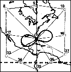
Let us remind ourselves that Clarkís primary example of this bowtie energy
is that which occurs in the general area of the
Bermuda Triangle, with its
opposite pole forming the eastern coast of Mexico. According to Dr. Clark,
the point at the center of the "bowtie" becomes a magnetic null zone of zero
gravity when appropriately triggered by the right geometric positions of the
Sun, Moon and Planets to the Earth. In those moments of conjunction, there
is a "hyperdimensional bleed-through," and we then get time dilations,
disappearances, gravity loss, levitation and other related phenomena.
In the next three pictures on the next page, the circular grid energy
formations surrounding the east coast of China and surrounding area are
easily seen.
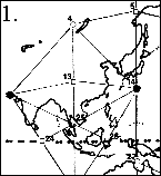 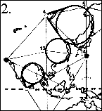 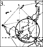
So, we can see that when you know what you are looking for, and you have
the
Grid map, these formations cannot be hidden. In picture number 1, we have
our straight grid map of China for comparison. Picture 2 has three circular
vortexes in it. We have already discussed the bottom left vortex in India
and China. Then, the center vortex shapes the East Coast of China, based off
of and emanating from point 13. The uppermost and largest vortex in Picture
2 shapes the entire Japanese and Russian archipelago, and is centered in and
emanating from point 4.
Finally, in picture number 3 we have a vortex centered in Sandersonís "vile
vortex" near Japan, the "Devilís Sea," here listed as
point 14. This vortex
is "equalized" by points 25 and 26, both of which are equidistant from the
edge of the circle. And obviously, the Philippines precisely traces the
bottom left of the circle itself. This is obviously a very strong vortex to
be able to shape the land of the Philippines from where it stands. According
to Becker and Hagens,
Another area of continuing disappearances and mysterious time-warps is the
Devilís Sea located east of Japan between Iwo Jima and Marcus Island. Here
events have become so sinister that the Japanese government has officially
designated the area a danger zone.
This area was significant enough to the work of Bermuda Triangle author
Charles Berlitz that he wrote a whole book dedicated to it and the "bigger
picture," entitled The Devilís Triangle. It is becoming more and more clear
that our geometric shapes, expressed as the consciousness unit expanded to a
planetary scale, are far more than abstract concepts of theoretical physics.
What we have here are direct, quantifiable and measurable phenomena, and
these geometry-based Grid patterns are simply the simplest, and therefore
the best solution to the problem.
If the reader wishes to see more of the connections between the Becker / Hagens grid and the landmasses, simply stare at the map for a while and they
start popping out. The reader will remember that in previous chapters, we
showed the "grid bands" on the Earth and how their effects shaped
the Ring
of Fire, the flowing of the Nile River, the "node point" of the Egyptian
northern coast centered in Giza, and the vertical structure of the Yucatan
Peninsula. Now, with the full map of the Becker / Hagens grid, we can see a
great deal more from the effect of these straight longitudinal lines.
As one example, by referring back to the main map, the reader can clearly
see that the entire Eastern side of Hudson Bay in Canada precisely follows
the line from 18 in Florida to 9 in the Bay to 61 at the North Pole.
Furthermore, all of England is precisely within the line created by point 20
in Africa, through point 11 in England to point 61 at the North Pole. So,
there are a variety of ways to see this energy at work on Earth. One can
begin to visualize this Grid energy as a living net of "wires" that are
tightly stretched over a thin balloon. It is obvious to us that what we
think of as randomly placed continents are actually conforming to this
massive energy.
As we look at the different diagrams of how these geometric energies show up
on Earth, we do indeed get a sense of the massive forces that are involved
with this Grid. We know that gravity is not the full extent of these forces,
either, as they can be shown to have profound effects on human
consciousness. Becker / Hagens explain how these Grid points also seem to
attract large population centers. We have shown that a pyramid is actually a
physical, crystalline structure that is built to be identical to our own
native dimensional frequency of the octahedron, for the purposes of
harnessing energy. The Wilcock reading in chapter 17 told us that the circle
shape of stoneworks like Stonehenge and earthworks like the
Mound Buildersí
creations in Florida also work to harmonize with this upward-spiraling Earth
energy.
Again getting back to our discussion of Dr. Clarkís information, we can look
back to the South American landmass. Not only does it fit perfectly within
our "Grid Triangle," but we can see yet another example of this circular,
"bowtie-shaped" energy at work in the actual shaping of the landmass itself.
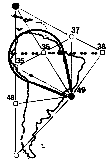
This "bowtie" is nearly centered within the diamond that is formed between
points 18, 35, 37 and 49. We already saw the African "vile vortex" shaping a
similarly large "bowtie" in the above diagrams. The offset of the South
American landmass from being precisely within this "diamond" again could be
accounted for by the pushing of the Mid-Atlantic Ridge, which follows the
lines of the Global Grid with amazing precision. Looking back to the Becker
/ Hagens map, it is quite easy for us to see how this line clearly
demarcates the separation between the continents, just as the Mid-Atlantic
Ridge is the point of expansion between the two continental plates.
We have just examined the circular energy formations caused by the Grid in
the Asian area of the Pacific Ocean. And here, we can see what happens when
we draw an even greater "great circle," based strictly on the island
formations in the Philippines area of the Asian Pacific.
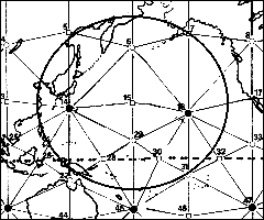
Here we can see that an elliptical-shaped gravity field is clearly visible
when the center is placed directly in node 15. If we use any standard image
editing program and "drag out" an ellipse using point 15 as a center, we can
indeed align it precisely with the island formations to the far west of our
diagram. We can try other center points besides 15, but the ellipse will not
fit anywhere else as precisely as it does right at that spot.
Right away, we should see that this very large energy vortex seems to
provide the clearest Grid counterpart for the existence of the Ring of Fire,
which is a ring of volcanoes and tectonic activity surrounding the Pacific
Ocean. When we look at this "grid ring" carefully, we can see that it
represents the perfect fusion between the Earthís landmasses and the Global
Grid. Going clockwise from the 12:00 point, the ring will perfectly touch a
"square" of grid points, as 7, 31, 27 and 5. (Node point 27, near Australia,
is the only one that isnít touched exactly, and this is probably due to
distortions in the map projection.)
We can also see that this ellipse is well defined by points 14 and 16, again
Sandersonís powerful "vile vortices," the points of the
icosahedron. We have
already seen how the gravitational force of these "vortices" was able to
shape the entire upper Western half of Africa into an elegant, circular
shape. Now, we are seeing two of these vortices working together to form an
even larger shape. The ring forms part of the East Coast of China, as well
as a good part of the upper Russian coastline surrounding node 5. It also
defines part of the southern coastline of Alaska.
Perhaps most interesting of all is that the combination of forces that are
demonstrating themselves in this map look very familiar to a microscopic
formation in nature. Take another look and you will see it… Cell Mitosis! We
can certainly see that Mother Earth is giving all Her secrets away, right in
front of our very eyes, if only we understand Her Grid. The grid points 14
and 16 would be akin to the two poles of the dividing cell. The gridlines
provide us with a simplified depiction of the "spindle fibers" that form in
cell mitosis. The actual ring of energy that is created forms a precise
analog of the nuclear membrane of the cell, as it continues its expanding,
elliptical process of division.
If this is interesting, it becomes even more interesting when we look at
page 31 of Robert Lawlorís book Sacred Geometry. There, he has printed a
diagram showing the eight stages of cell mitosis. Eight is the number of the
octave, hence Lawlorís quote:
From one cell to two there is a cycle of change, in eight phases with seven
intervals, analogous to the musical octave, or the spectrum of light. Seven
symbolizes such cycle; the lunar month, a perfect example of graduated
phases within a continuous process, is dominated by seven and its multiples…
The functional pattern of the human nervous system is also sevenfold…
In other words, we can see a very direct analog of the "consciousness unit"
yet again in the cell; a process of division with eight stages in seven
intervals. The human nervous system, as Lawlor explains in his book, also
shows us this octave structure. Now, we can see the Grid counterpart to
this, which occurs through hyperdimensional geometry that is octave-based.
So, you might be wondering, what does this mean? Why does it matter if there
is an octave pattern in cell mitosis or the human nervous system? We can
look back upon previous chapters and see all the clues. Sources such as the
Cayce Readings and the
Ra Material tell us that
we live in an octave-based,
eight-dimensional universe. We then observed the world of cutting-edge,
modern "superstring theory" physics and discovered that with one slight
adjustment, they have discovered the same thing. Srinivasa Ramanujanís
divinely inspired ímodular functionsí are all octave-based.
We have cited numerous spiritual works that tell us that the One originated
as Pure White Light, and fragmented down into the octave or spectrum of
frequencies or dimensions. Each discrete interval represented a different
aspect of this Wholeness. We know from basic intuition, as well as sources
like the Ra Material, that Nature will provide us with physical metaphors to
explain the metaphysical. Look at the structure of the seashell and its
depiction of the phi spiral, for example. In Lawlorís book Sacred Geometry,
we can also see numerous examples of the Renaissance scientists making clear
connections between these harmonic ratios and the proportions of the human
body. As we continue to explore these issues, we can indeed see what
transcendental significance the human body actually has, built directly into
its design. Or, as the saying goes, "Man is the measure of all things."
We can now see that the cell division is another natural example of these
sacred, octave-based mathematical principles showing up in the physical
universe. The original cell would represent the sphere, or the first note of
the octave. There are then seven stages, or frequencies, that cause cell
division to form. Then, at the final stage, the eighth, we now have two
cells, and the division is complete- the original form has again emerged,
only now having produced a precise copy of itself.
This also is akin to the octave structure in the atom, where each electron
that is released puts the atom through different isotopic stages. Once you
break the "octave" threshold, the atom metamorphoses into the next element
in the Periodic Table. In other words, this process of energetic expansion,
emerging from the central core, or nucleus, or Sun, produces an evolution in
the actual form of its entire structure. This is the way that all
consciousness units operate, whether it is sub-microscopic, atomic,
cellular, planetary or even Solar System-wide.
We know that the system of geometry for the CU is also harmonic and
octave-based, and thus we see these Platonic forms emerging in minerals, in
the organization of cells in a developing zygote, and in the planetary grids
themselves. We also know that these frequencies are governed by very simple,
harmonic numbers. These numbers show up when we measure the vibrations of
sound frequencies in air. Therefore, when we see these same frequency
numbers for the CU emerging in the Great Sunspot Cycle in later chapters, we
can see that a similar division and enhancement is occurring in our Solar
System as a part of this fundamental, interweaving system of energetics.
This is yet again another reason to see why we are so quickly heading into a
spontaneous dimensional shift here on Earth, or the Single Greatest Moment
of All Time.

|


