|
Cataclysms of the Earth
By Hugh Auchincloss Brown
INTRODUCTION
We are all aware that our earth is constantly changing. By the
roadside or in the mountains we notice the layers of rocks, or
strata, displaced from their original horizontal plane, and
recognize the evidence of the shifting of the earth’s so-called
crust In the cross sections of canyons we note the succession of
layers-the permanent markings made by rock formation in earlier
epochs. We uncover animal and plant fossils and by their depth and
placement can construct a chronology of prehistoric life. The
movement of the rivers carving out new beds and the pounding of the
oceans on their shores all remind us of the endless motion of the
land and seas.
These, however, are but the surface phenomena of the evolution of
our globe. Barely do we speculate on the forces constantly reforming
the planet as a whole; rarely do we speculate on the nature and the
effects of major upheavals and cataclysms that, on a larger scale,
have characterized the history of the earth. We are all aware of the
great stone book that is our earth, but rarely do we read its pages.
The origin of our planet remains a mystery; of its life history,
inscribed upon itself, only minutiae are fully known to man.
The successive layers in the earth’s crust reveal that the earth has
not only undergone vast surface changes, such as the stratification
of layers of rock and the formation of mountain ranges and river
beds. On a much grander scale, the evidence suggests that the
earth’s axis of rotation has repeatedly changed its direction;
during its journeys around the sun the earth has been rolling
sideways as it spins in daily rotation, and shifting to a new Axis
of Figure, i.e., the axis defining the geographic poles.
Page 2
|

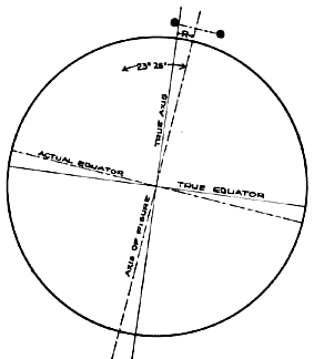
Fig. 1. Deviation between true axis and Axis of Figure.
|
Such an axial shift can best be understood when considered in
relation to the earth’s rotation about the Axis of Spin-the true
axis of rotation in respect to the stars and irrespective of the
surface terrain of the earth. The Axis of Spin is the imaginary line
in space about which the earth rotates; it is constant in relation
to the earth itself, but changes its position in space as described
later. The Axis of Figure is an imaginary line through the center of
the earth; it is defined by the arbitrary designation of the
geographic poles, wherever they may occur during any epoch, and,
being relative to the geography of the earth’s surface, it changes
whenever the earth shifts about the Axis of Spin.
Page 3
Although the earth has continued to rotate on the Axis of Spin that
passes through Polaris in the northern sky and the
Southern Cross in
the southern sky, it has in the course of time turned sideways or
"careened" in its spinning; the geographic positions of the poles,
the Equator, and the various zones of the globe, have been redefined
in respect to the surface terrain. During such careening the Equator
tilts, and the poles, defining the Axis of Figure, rotate away from
the Axis of Spin. All areas of the globe, except those two
points directly on the Axis of Careen, are altered in relation to the Axis
of Spin, and hence in relation to their previous climates. A land
mass or ocean, once in an equatorial zone, is shifted towards a
polar position; the poles shift around towards the equatorial zones.
The previous Axis of Figure is then replaced by a new one,
determined by the new geography of the earth. At the beginning of
each epoch, the Axis of Figure and the Axis of Spin coincide.
Fossils of animal and plant life from previous epochs serve as
telltale indicators of the climate prevailing when the strata in
which they are found formed the earth’s surface. From fossils and
other evidence we are able to document the displacement of materials
from their native climates to areas of new and often alien climates
and to designate the amount of displacement and the date of earlier careenings of the globe. From the condition of the evidence, we are
able to suggest the cataclysmic forces that took effect at such
time.
This evidence, however, provides us only with the symptoms of the
forces at work on our planet. To fully understand why the earth has
come to be as we know it, we must also analyze how it came to be
that way.
We must construct a theory, consistent with all the data that we can
collect, which will explain how such careenings have come about. And
we must test this hypothesis by applying it to the earth as we
presently know it.
Here again, all the evidence mentioned so far will serve as our
guide. Indeed, the discovery of the recurrent careening of our globe
resulted from efforts directed at solving the mystery of prehistoric
animal life.
Page 4
The value of any branch of science, even such a seemingly "backward"
looking one as geology, lies not only in the knowledge we may gain
about the past and the changes and developments that have occurred.
For science to be of value in the present, for it to transcend the
mere recording of the past and present, it must offer theories that
are applicable to the future.
Years of investigation and research, coupled with resolution and
courage to follow wherever truth might lead, have established the
certainty of a future world cataclysm during which most of the
earth’s population will be destroyed in the same manner as the
mammoths of prehistoric times were destroyed. Such an event has
occurred each time that one or two polar ice caps grew to maturity;
a recurrent event in global history it is clearly written in the
rocks of a very old earth.
The earth is approximately 4 1/2 billion years old. Human beings
have been living on it for at least 500,000 years and perhaps even
one million years. To appreciate the immensity of these figures, one
might imagine the age of the earth represented by the period of
about one week; the duration of our own epoch, 7,000 years, is then
but one second! By a similar analogy, men have lived on an earth
that is one week old for just two minutes. It is evident that our
own epoch is but a very short and insignificant period in the life
of our planet and our species.
In past epochs there have been ice caps at one or both of the
geographical poles. The heat of the sun caused these ice caps to
grow larger. As the sun heats the air of the hemisphere, the heated
air expands, becomes lighter, and rises. The updrafts are greatest
in the tropics. As the earth is virtually spherical, the currents of
warm air converge at the poles. Meeting head-on from every
direction, they create areas of air pressure, become colder and
heavier, turn downward, reversing the direction of their flow, and
pour back toward the Equator from the polar centers with high
velocities. Thus, there is a continuous circulation of rising humid
warm air journeying poleward and a down draft of cold dehumidified
air returning from the poles at low or ground altitudes. Air acts
like a sponge. When warm, it absorbs water; when cold, it cannot
hold much water, and in cooling releases any surplus moisture to
fall as rain or snow.
Most of the snow that falls in the polar regions does not melt; the
air temperature is too low. Instead, the snow is stored, changing to
glacial ice. As this process continues through time, the ice masses
at the poles constantly grow in volume.
Page 5
As the prehistoric ice caps grew larger, they tended to throw the
rotating planet off balance because of the wobble of the earth,
causing the earth to roll around sideways to its direction of
rotation.
Another analogy will make this clear. When you place a weight at the
end of a string and then rotate the string in a circle, the weighted
end of the string rises to a horizontal plane. Now, imagine yourself
and the string as the earth, the weight at the end of the string as
the weight of a growing ice cap, and imagine that, instead of
intentionally swinging the weighted string, the rotational motion
encompasses you, the string and the weight, as though you were
standing on a rotating platform. In this depiction, then, your body
represents both the present Axis of Spin and Axis of Figure of the
earth. Your body does not move; the Axis of Spin remains the same.
But your arm and the weighted string, here representing a radius of
the earth, rise from the vertical (directed towards the pole) to the
horizontal (directed towards the Equator). The sphere of which your
arm and the weighted string are a radius is rolled sideways; the
weight, representing the imbalance of an ice cap, rotates from a
polar position to an equatorial position. The Axis of Figure,
previously represented by your vertical arm, is now changed; the old
Axis of Figure is now perpendicular to the Axis of Spin.
The rotating equilibrium thrown off balance by the weight of the
growing ice caps, causes the spinning globe to roll over on its
side. But such an event does not occur lightly. The oceans, like
water in a bowl that is suddenly moved, are cast from their basins
to flood the land. The winds, previously settled into patterns
dependent upon a stable globe, are whipped asunder by the sudden
shifting of the globe. The sudden meeting of warm and cold air
creates great pressure zones that spawn new rains and hurricanes to
sweep across the earth. The forces of nature, loosed from their
equilibrium, rage wildly in search of a new equilibrium.
The Great Flood of Noah’s day resulted from the latest careening of
the globe. As we shall see later, records indicate that he had been
living in what is now Madagascar or South-east Africa-then about as
far from the North Pole of Noah’s epoch as New York City is from the
North Pole of our day. At that time a land area containing the ice
cap was at the North Pole. And on that day the globe careened,
without changing its speed of rotation, through about 76 degrees of
latitude. The ice cap rolled to what is now called the Sudan Basin
of Africa, where it simply melted in the sunshine of the tropics,
leaving tracks of its flow-off.

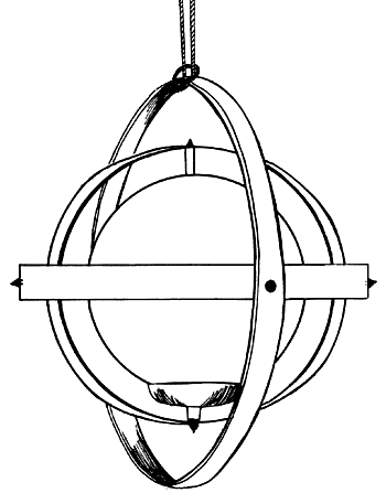
Fig. 2. A small wooden globe representing the earth, with a small
lead weight at one pivot representing an oversize polar ice cap at
the South Pole, is supported in trunnions so that the globe may move
in any direction. When a horizontal spinning motion is imparted to
this laboratory model by the untwisting of the suspending cord, the
lead weight promptly moves to a horizontal position, demonstrating
the careening motion of the earth.
Every continent contains many groove marks of prehistoric ice ages.
The slithering movements of towering glaciers have scoured the rocks
over which they flowed, leaving a permanent record from which we can
reconstruct their travels. And the groovings, all radiating from the
center of the glacial areas, disclose the location of the former
North and South Pole areas, corresponding in size to the areas now
contained within the Arctic and Antarctic Circles.

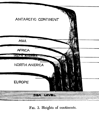
Fig. 3. Heights of continents.
Page 8
The present ice cap in Antarctica is merely the last of many
thousands that have previously existed. Geological records reveal
that it is the successor to a long lineage of glistening assassins
of former civilizations of this earth. A minor ice cap also exists
today, on the fringe of the Arctic Ocean, mainly in Greenland.
The enormous size of the South Pole Ice Cap is difficult to grasp.
Were it centered in United States with the South Pole in North
Dakota, its area would extend to the Atlantic and Pacific Oceans, to
Mexico on the South and to the northern extremity of Canada on the
North. The ice would stand two miles high at North Dakota, and
icebergs would flow off into both oceans on a slope of about seven
feet per mile. It would take one thousand four hundred cakes of ice
the size of Lake Superior, with an area of almost 32,000 square
miles, to equal the ice mass now accumulated on the Antarctic
continent!
As large as the present ice cap is, however, there are two factors
presently functioning to prevent, or at least inhibit, any immediate
cataclysm similar to the ones of earlier epochs. The stress however,
must be on the word "immediate," for these factors, one favoring the
stability of the earth in rotation, and the other limiting the
growth of the ice cap itself, existed in earlier epochs as well.
The earth only approximates the shape of a perfect sphere. The
diameter of the earth at the poles is shorter than the Equator, a
fact which suggests a slightly flattened sphere somewhat the shape
of an apple. It is for this reason that when land areas on the short
or polar axis roll around to where the long axis had been, as
happened during earlier cataclysms, some land areas go below sea
level. A new arrangement of land and ocean areas and a new
equilibrium or isostasy are established for the ensuing epoch. By
the time the careening and the flood are over, the top strata of the
earth become readjusted to the new Axis of Figure and a new
equatorial bulge is in time established.
Page 9
Our globe today is stabilized, and held to its present Axis of
Figure by the centrifugal force of this equatorial bulge. The
gyroscopic energy of the rotating bulge steadies the globe and
prevents it from rolling haphazardly. The earth thus functions in
the manner of a flywheel. This mechanical energy acts like one jaw
of a nutcracker whose other jaw is the energy of the "throw" of the
eccentric centrifugal force of the rotating polar masses. The energy
of these two jaws pinches certain of the upper layers of the earth
strata until the pressure exceeds the resistance offered by the
materials of the earth and causes a crumpling and elevating of earth
layers in some places. The energy of the "throw" increases with the
square of the speed of motion which in turn increases directly with
the distance off center, thus overcoming the stabilizing effect of
the earth’s bulge and causing the globe to roll sideways to its
direction of rotation.

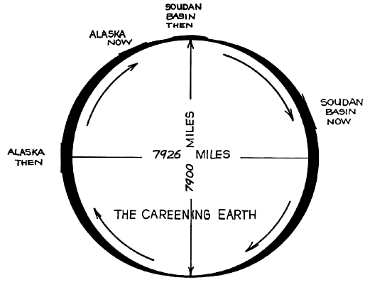
FIG. 4. Cross section (greatly exaggerated) of the bulge of the
earth during the previous epoch of time.
Alaska was on the 13-mile
bulge of the earth then. It is now roughly 10 miles nearer to the
earth’s center.
The Sudan Basin Ice Cap was on the shortest diameter of the earth,
at the North Pole. The Sudan Basin is now near the longest diameter
of the earth, near the equator, roughly 10 miles farther from the
earth’s center.
Page 10
Although this bulge is important dynamically to the maintenance of
the equilibrium of the globe and the formation of the earth strata,
it is smaller in size than is generally realized. Limited by the
force of gravity, equal and opposite in direction, the bulge has a
maximum of about 6 2/3 miles at any point along the Equator, with an
equal shortening at each pole. Since the best of ivory billiard
balls warp from their tendency to absorb moisture, the earth is
actually a truer sphere than a billiard bill, being true within
about one-sixth of one per cent.
The other factor preventing an immediate cataclysm is a function of
the dynamics
of the ice cap itself. At present the glacial ice of Antarctica
flows by its own weight and pressure, streaming through valley
openings in the coastal mountains to the oceans where it flows away
as icebergs. This disintegration, plus normal evaporation, provides
a safety valve which gives our generation a chance to live on this
earth. But only temporarily.
The discovery that the great South Pole Ice Cap is growing, rather
than waning, as previously supposed, confronts us with an entirely
new understanding of the limited time during which our present
civilization has been developing, and the precariousness of its
continuation. We are faced with the alternative of limiting the
growth of the ice cap or accepting a limit to the duration of our
present epoch.
The growing South Pole Ice Cap has become a stealthy, silent and
relentless
force of Nature-a result of the energy created by its eccentric
rotation. The ice cap is the creeping peril, the deadly menace, and
the divinely ordained executioner of our civilization. just as a
sword, suspended by a single hair, hung above the head of Damocles
at Dionysius’s banquet, so today the baneful jeopardy of an impeding
world flood hangs over all of us.
Page 11
This book will make it clear that, if we wish to continue to inhabit
the earth we must control the further growth of the great South Pole
lee Cap.
The elemental forces of Nature that are involved are now known and
they are
clearly identified. If we procrastinate and do nothing, the Flood
will occur when the present polar areas move away from the earth’s
Axis of Spin, and the Poles of Figure move to latitudes of ten to
fifteen degrees, or about 5,500 miles away from the North and South
Poles of Spin.
The earth will tip over, like an overloaded canoe
towed in a circle behind a power boat, in consequence of the wobble
of the earth and the resulting eccentric centrifugal force of
rotation of the present South Pole Ice Cap and its constantly
increasing weight. The earth of today may quite readily be compared
to a top-heavy, dying out, wobbling, spinning top, getting ready to
fall over on its side.
|


