|
III -
MAN: THE PAST, THE PRESENT, AND THE FUTURE
The Survival of Civilization
MEN of science have discovered and collected records showing that
human beings have existed on the earth for a half million .to. ’a
million years. They have identified Java Man, Neanderthal Man, and
other anthropological specimens, which they date back a very great
number of years.
Our present civilization has developed during our present epoch of
time, approximately 7,000 years. This epoch compares to the age of
the earth 432’ billion years approximately as one tick of a, clock
compares to all the ticks of the same clock running constantly for
approximately seven days, with one tick for each second.
Keeping in mind these tremendously different time scales, we find it
especially significant when qualified students of ancient history
inform us that the historical records of the earliest civilizations
such as Assyria, Babylon, and Egypt
arose about 5000 B.C., and that
prior records are legendary.
Authentic history concerning groups of human beings, therefore,
began about 7,000 years ago. We know very little about the history
of man prior to that last great Flood which destroyed most of the
inhabitants of the earth. Our knowledge of history is limited to
probably less than one per cent of the time that men have inhabited
the earth.
Page 137
Through migration the descendants of those who escaped destruction
by the Flood have spread over the surface of the earth; most of the
populations of Europe and America came from the east; and the
migrations of peoples and the histories of nations attest to the
fact that these land areas and continents are rather new, and that
it is only in fairly recent times that they have become established
in the locations that we know today.
The equivalent of our present world population of over two billions
of people could be created in a little over 600 years. if one male
and one female survived after a world deluge and had six children,
and each pair of children had six children during nineteen
generations. The nineteenth generation alone would number over two
billion.
There are three places, possibly four, on the earth’s surface which
were not submerged in water during the last Great Deluge. They are
areas which, during Epoch No. 1 B.P., were at the North Pole, the
South Pole, and at the two pivot points on which the earth turned as
it careened the points which correspond to the poles of that
transient axis.
The North Pole land area, which then comprised most of what is now
Africa, careened until the center of the ice cap which had been at a
latitude of 90 degrees arrived at a latitude of about 10 to 15
degrees, or approximately at what is now Lake Chad in the Sudan
Basin of Africa.
The centrifugal force of that reeling ice cap pulled the land out
and away from the center of the earth and, together with the
centrifugal force of the spinning earth, left those land areas about
13 miles farther away from the center of the earth than when it was
at the North Pole. As previously explained, the force of that pull
was so great that most of the land areas of the earth are in a "Land
Hemisphere."
During the careening, the centrifugal force of the Sudan Basin Ice
Cap apparently caused the land to rise above sea level, for the
adjacent land of Egypt appears to have escaped the Flood. Records
seem to indicate that animal life there was not extinguished.
The South Pole Ice Cap area of Epoch No. 1 B.P. also reeled to the
latitude where the old bulge of the earth had existed, and to
approximately 13 miles farther from the center of the earth than
when it was at the South Pole. This land area may have become
submerged.
Page 138
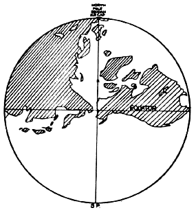
FIG. 5. Approximate positions of land areas during the previous
epoch of time.
Alaska and the United States of America were in a
tropical climate.
The Sudan Basin of Africa was at the North Pole.
X
marks the temporary geographical location of the North Pole for our
present epoch.
The survival of animal life there is not so clearly established as
in the case of the North Pole Ice Cap region principally because
islands alone mark its approximate location.
It seems probable that the short duration of Epoch No. 1 B.P. was
due to the existence of two ice caps, and that the North Pole Ice
Cap was the larger, because its centrifugal force of rotation
brought about the greater elevations now found in the Land
Hemisphere.
The two pivot areas of the earth were not submerged. They were
located on the earth’s bulge at the Equator before the earth
careened, remained on the bulge during the great Flood, and are now
on the bulge of the new Equator. Except for tidal waves, coming from
disturbances in other areas, these sections of the earth’s surface
escaped the Flood, a fact which explains why animal life appears not
to have been extinguished in the two pivot areas.
The evidence for the continuance of animal life in the former North
and South Pole areas, and in the pivot point areas on which the
globe careened, will be discussed below. Page 139
THE FORMER NORTH POLE AREA included Egypt, which borders on the
Sudan Basin, and in that country originate some of the earliest
records of our present civilization. Egypt escaped the Flood, for at
the "dawn" of Mediterranean history the nation appears to be mature,
old, and entirely without mythological and heroic ages as if the
country had never known youth. At the time of Menes, the first king,
the Egyptians had long been architects, sculptors, and painters.
Relatively speaking, the civilization of ancient Egypt, upon its
first appearance, was of a higher order than at any subsequent
period of its history a fact which indicates that it drew its
greatness from a fountain higher than itself or at least its equal.
The civilization of old Egypt did not go through a period of
infancy; it was mature when it first appeared on the stage of
history.
The legend of the great Flood was not current in historic times
among the Egyptians nor among the black races, according to Ignatius
Donnelly, but it occurs almost everywhere else. The Assyrians and
Babylonians had traditions of a Flood. Abraham migrated from Ur of
the Chaldeans, near the head of the Persian Gulf. His grandson,
Jacob, with his twelve sons, moved farther westward into Egypt, so
that the Egyptians of that period must have heard about the Flood,
though they seem to have escaped it.
The Egyptians were doubtless indigenous; the ancestors of Abraham
arrived in Mesopotamia by boat. The records of the Egyptian priests
antedate the Flood. The priests of Memphis reckoned back 11,000
years. The priests of Thebes told Herodotus that they reckoned back
17,000 years.
The Egyptians appear to have been living on the edge of a glacial
continent during Epoch No. 1 B.P. The center of Egypt’s earliest
civilization was about as far from the North Pole of Epoch No. 1 B.P.
as Fairbanks, Alaska, is from the present North Pole. This cold
climate could account for the absence of many vegetables and fruits
in early Egypt such as the fruits and vegetables, listed presently,
which have been found to have survived only in the pivot point areas
of the earth.
Page 140
An interesting but mythological clue to the land of Egypt being
related to a region to the north and to the land of the early
contemporaneous Suzerains, a pre Babylonian civilization in the
Euphrates Valley, which suffered a flood, is referred to by an
eminent scholar:
"The Osiris story was the best known and most
influential of the Egyptian myths. He introduced agricultural,
animal husbandry, and arts and crafts to Egypt After his death he
returned to his original home, from which agriculture, animal
husbandry, and arts and crafts to Egypt. raised. Osiris’s home was
not in the west, as is usual with such happy hunting grounds, but in
the north. The land was foggy and bordered with high mountains...
Toward the mountains rose a dense forest . . . Many of the trees
were conifers, sacred to Osiris.
"A similar mystery surrounds the origin of the Suzerains, the only
people known to have had writing as early as the Egyptians. They
brought their language into Lower Mesopotamia... after a flood of
the twin rivers had wiped out some of the more vulnerable
settlements of the earlier inhabitants... The date of the flood
is estimated at about 3000 B.C."
(The Story of Man, by Carleton S.
Coon pages 238 9.)
From the Near East four historical traditions have come down to us
concerning the earliest inhabitants of that region. The Babylonians
held to a tradition that they were descended from persons who
survived the latest great deluge which destroyed everyone else.
Their ancestors had survived in an Ark, which had come to rest on
the mountain of Naysayer thought to be in the vicinity of
Teheran,
Iran.
The Greeks claimed descent from Hellen, son of Deucalion and his
wife Pyrrha, who survived a great Flood which destroyed all others.
They landed on Mount Parnassus in an Ark or chest. The Jews have
given us the story of Noah, who with his wife, three sons and their
wives were carried safely through a great Flood which destroyed all
others. They landed on Mount Ararat in present day
Armenia.
The Koran informs us that Noah and other believers were the only
ones to survive a great Flood. The Ark in which they were saved came
to rest on Al Djoudi. Noah’s son perished in the great waves,
because he was too late in embarking.
Page 141
Remains of a vessel declared to be the Ark were found on
Mt. Judi,
on the left bank of the Tigris River, in the eighth century A.D. The
remains were exhibited in a mosque and monastery of commemoration
and were viewed by travelers and visitors from far away. The
buildings were struck by lightning and burned to the ground in 776
A.D.
Each of these historical traditions is believed by many millions of
differently educated people. Assuming that all four are true, then
modern man must have had a great number of Flood surviving ancestors
in the Near East.
THE FORMER SOUTH POLE AREA This region approximately encompasses the
present Samoan Islands in the Pacific Ocean. Many Polynesian peoples
have traditions to the effect that the center of dispersion of the
race over the Pacific Ocean from Hawaii to New Zealand was Savaii,
which is the largest of the Samoan Islands. Its highest elevation
above sea level is now about one mile. Historians have remarked on
the absence of any Flood tradition among the Polynesians of Oceania.
The Transient Axis of Careen
THE poles of this axis were the pivot points on which the globe
careened. They were on the Equator before the latest careen of the
globe and remained on the Equator after the careen. The compass
points changed. The climate remained unchanged.
THE WESTERN PIVOT POINT AREA is now known as Peru and
Ecuador, in
South America. It was a Safe Area for peoples and civilizations.
Their descendants included the Incas, who continued to live in a
mountainous region, usually not a natural place for a civilization
to start.
Page 142
The Inca civilization like Egyptian civilization appears to have
drawn its early greatest from a source perhaps higher than itself,
for numerous basic food plants, on which previous civilizations no
doubt depended, have been first discovered as growing in or nearby
this pivot area. These same vegetable species were obliterated by
the Flood everywhere except in pivot point areas.
Maize (corn), white potatoes, tomatoes, and certain beans including
Lima beans were all found originally in this area and nowhere else
in the world. They are indigenous to Peru, Ecuador,
Bolivia, and
northern Chile. Sweet potatoes, squash, and
peppers were first found
in nearby areas, including Central America, Mexico, and the
West
Indies.
Seeking traces of some of these vegetables in the opposite Safe
Area, or eastern pivot point, where pre Flood civilization was
similarly not destroyed, we find that cobs and kernels of popcorn
identical with the corn found in graves in Peru have recently been
found among the backward peoples in the Naga Hills, where
Burma
meets Assam.
It could be glossed over as no more than a coincidence that maize
has been discovered as an original food in both pivot point areas of
the latest careen of the globe, were it not for our previous
assumption that not only maize but also others of the western pivot
point area vegetables would be discovered in the eastern pivot point
area.
THE EASTERN PIVOT POINT AREA, now known as Sumatra and the
Malay
Peninsula, was a Safe Area. This fact accounts for the civilization
of Asia being older than that of Europe. Europeans have generally
considered some place to the east as having been the birthplace of
the human race. Migrations of people have continually come from the
east, pushing westward.
Most of our fruits came to Europe from the direction of the Malay
Archipelago. Apples, pears, cherries, figs, olives, and most of our
plums and grapes have been traced to the eastern Mediterranean and
to the Caspian Sea areas. Peaches, apricots, bananas, mangoes,
oranges, and lemons have come originally
from regions farther to the south and east. Much botanical evidence
points to Malaysia as the ancestral home of the coconut though its
definite origin is still in some doubt. (Authoritative accounts of
the origins of our vegetables and fruits are contained in The
National Geographic Magazine. For greater details, see "Our
Vegetable Travelers", in the August 1949 issue, and "How Fruit Came
to America", in the September 1951 issue.)
Page 143
Five distinct races of men are generally recognized by
anthropologists a race being the descendants of a common ancestor,
or family, tribe, people, or nation believed to belong to the same
stock or breed. These five races are the Caucasian or white race,
the black, yellow, red, and Eskimo. There are also distinct
subdivisions such as Pygmies, Bushmen, etc.
The careening globe theory may aid in identifying more clearly why
these races are found where they are now. The Egyptians, for
example, lived in a cold climate and were moved to a tropical
climate, where they flourished.
The Eskimos of today probably lived in a tropical climate during
Epoch No. 1 B.P. They are now in a frigid climate and have survived
because they have managed to adjust to their environment. The
mammoths of that same period perished when moved to the arctic
regions, being unable to adjust to the new climate.
The Eskimos might become as prominent in the next epoch as the
Egyptians were at the beginning of our present epoch.
The Migration of the Present Ice Cap
WHEN the earth careens due to the combined centrifugal pressures of
the Antarctic Ice Cap and the Greenland Ice Cap acting along the
same Great Circle, the event will be heralded by earthquakes along
the Equator at 45 E. longitude, which is just off the African east
coast and at 135 W. longitude, which is in the Pacific Ocean.
Those are the locations of points which are 90 distant, east and
west, from the assumed points of application of the eccentric
ice cap forces which are tending to change the angle of direction of
the motion of the gyroscopic bulge of the earth. Those are the
places where the maximum effect of these pressures would occur. The
result of the pressures, if continuous, would be to produce a
movement in the earth’s strata at one or both of those locations. (
This is discussed later on under "The Four Safest Areas for Animal
Life.")
Page 144
The earth gyroscope differs from a commercial gyroscope. Its
internal parts adjust themselves automatically to the pressures
exerted on those parts. Therefore, as earth parts yield to
pressures, break down, and readjust themselves, a different
careening motion of the globe occurs than is apparent in the
commercial gyroscope.
The careening will not occur at a 90 distance from the point of
application of the force, because the energy of the rotating earth
bulge, against which the energy of the centrifugal force of the off
center ice cap is applied, changes its direction of motion and its
geographical location as soon as the bulge starts to move.
The initial start of the careening of the globe will result from a
yielding of earth materials along the bulge, near the Equator, at a
90 distance from the point of application of the force.
Once this change of location of a part of the bulge has started, the
predominant force will be the ever increasing centrifugal force of
the off center elements of the ice cap, which increases at a rate
equal to the square of the speed of motion, and which, in turn,
increases directly with the increase in distance off center, plus an
increment due to the lessening pull in the opposite direction by the
ice mass on the opposite side of the Pole of Spin as the ice cap
moves sideways across the Pole. Thus, an enormous and rapidly
increasing force is developed which carries the ice cap rapidly away
from the Pole and toward the Equator.
Page 145
Due to the curvature of the earth, the "throw" toward the Equator
will lessen as the distance from the Equator lessens. Meantime the
force of the kinetic energy of the entire ice cap will have taken
over as the predominating force, and it will become blended with the
kinetic energy of the rearranged materials of the new bulge of the
earth into one gyroscopic force.
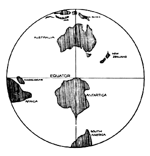
Fig 6. The earth after the next careen, Antarctica area. Careen
assumed on 135 o E. longitude.
The antarctic Ice Cap has moved to
near the Equator and this hemisphere will become the land
hemisphere, with emergence of more land.
The center of the ice cap will reach a point on the new bulge within
about 10 to 15 degrees of latitude from the Equator. Distance R will
have become roughly 5,500 miles and, due to the increased speed of
its motion, the kinetic energy of the rotating and reeling ice mass
will have been increased to billions of times what it was at the
start.
The start of the ice cap on its migration from the South Pole Axis
of Spin to a point near the solar Equator, will occur for reason No.
1 (below), which may be influenced by reasons No. 2 and No. 3.
1. The ice cap’s migration will start because of a yielding of earth
materials, somewhere on the earth’s bulge, due to a change in the
angle of rotation of the earth gyroscope, responding to the pressure
of the centrifugal force of the ice cap. The first yielding will
occur at a place which will become a pivot area when the earth
careens, as the previous explanation of the gyroscope indicates.
Page 146
At the start, the ice cap is just enough off center to exert a force
sufficient to cause earth materials to yield somewhere. An
earthquake occurs. If the earthquake does not relieve the pressure,
it becomes cumulative for the reason that a crack up of the earth in
one place removes that area from the front line of defense, and
throws the burden of resistance on other areas, while any yielding
of the earth which permits an increase in the distance between the
true axis and the center of gyration of the ice cap, increases, in
proportion to the square of the distance, the throw of centrifugal
force of that part of the ice cap which is not counterbalanced by
the throw of the ice mass on the opposite side of the pole.
2. It may start because changes in the isostatic balance of the
earth due to shifts of materials elsewhere on the globe are of
sufficient magnitude to throw the Pole of Figure destructively off
center.
Normal changes of the isostatic balance of the earth occur slowly,
due to such rearrangements of materials as:
a. Accumulations of glacial ice
b. Changes of shore lines resulting from lowering of ocean levels
c. Diversions of water courses
d. Impounding of water in artificial reservoirs
e. Shifting of sand and dirt by the winds
f.
Growths of forests and bogs
g. Concentration of weights of materials in city areas
h. Extraction of oils and minerals from underground
3. It may start because of changes in the directions and intensities
of the forces of celestial radiation, whose impact on the earth’s
materials cause its rotation. Minor changes produce a slight
wobbling motion of the earth, as explained in Part II. The
centrifugal force of the earth’s bulge readjusts the Axis of Figure
to these changes.
Some disturbances of the heavenly bodies most closely associated
with the rotation of the earth such as the near approach of a very
large comet might cause the position of the earth’s
Axis of Spin to change too rapidly. A sudden change in the
directions of the driving forces which rotate the earth, could move
the Axis of Spin so far out of coincidence with the Axis of Figure
that the stabilizing influence of the centrifugal energy of the
earth’s bulge would be overcome before it could readjust the Axis of
Figure to the new position of the Axis of Spin. The larger and
heavier the polar ice caps become, the more difficult these
readjustments become.
Page 147
The migration of the ice cap from pole to equatorial bulge will be
marked by a slow start, by a rapidly increasing acceleration for the
first half of the journey, and by a slowing down to a full stop
before it reaches the Equator.
Whatever the cause of the migration of the ice cap, the consequence
which follows is that the earth careens. The direction of its travel
will be along a longitudinal meridian line with a slight veering to
the east, caused by gravitational pressures.
The last stage of the migration of the ice cap from the Pole to the
Equator of Force (EQUATOR OF FORCE: term devised by author, meaning,
as the earth careens, the bulge of the earth changes latitude about
80 degrees. At any particular time during the careen, the Equator of
Force is located at the bulge of force.) will be marked by a slowing
down and final cessation of all latitudinal motion. It will become a
part of the new equatorial bulge. Its speed will be that of the
bulge, and the centrifugal forces of the ice cap and of the earth’s
new bulge will be merged into one centrifugal force.
The elevation of the ice cap will be approximately 13 miles farther
from the center of the earth than when it was at the Pole. Two areas
of the earth which were near the old Equator will become the new
North Pole and South Pole. They will each be approximately 13 miles
nearer to the center of the earth than when they were near the
Equator.
To an observer at some point on the deluged parts of the earth it
would appear that the bulge was moving. The bulge would appear to
move like a huge underground wave or earthquake, as it remained in
its true position of force at the true
Page 148
Equator and the lands and seas passed across it. If, however, the
observer looked up at the sun, moon, and stars instead of watching
the earth, he would see that he was moving with the earth, and would
feel that there was a rapid change of climate.
If the observer is standing at one of the pivot points of the
careening earth, he will find that the compass points will change.
The sun will strangely appear to rise in the south and set in the
north, at one pivot point because the land he bad known as being
south of him would be to the east. Similarly, at the other pivot
point the sun would appear to rise in the north and set in the
south.
Herodotus was told by the priests of Memphis there bad been,
"341
kings and 341 high priests in 341 generations during 11,000 years,
and in that space, as if to corroborate their genealogy, the priests
asserted that the sun had risen twice where he set, without
affecting any changes in their climate or the productions of the
country."
This reference to two changes in the relative geological
points for the risings and settings of the sun in ancient Egypt,
fits perfectly into the pattern of the careening globe theory,
though failure to note some change in climate casts a doubt.
In the tomb of Senmut, the architect of Queen Hatshepsut of the
XVIII Egyptian Dynasty, there is an astronomical ceiling panel which
shows the Orion Sirius group of stars proceeding in a direction
opposite to their present motion. This panel could well have been
made to commemorate an earlier historic period when the stars of
Egypt did appear to be going in the reverse direction, and, if so,
would confirm that east and west were actually reversed, as related
by Herodotus.
Assuming, for illustration, that on the day of the latest careen of
the globe, it was 9 o’clock in the morning in Memphis when the globe
began to careen sideways while continuing its normal west to east
rotation; people would then have observed that the sun appeared to
stand still or to wander erratically, and to finally set near where
it had risen then considered to be the east. During that day,
possibly before 6 o’clock, the east and west had changed places.
Since people did not know that the
earth was rotating and careening, they considered that they had seen
the sun stand still and then move backward.
Page 149
This is all simply explained. The Sudan Basin was at the North Pole.
Lake Chad was the central point. The ice cap rolled around to within
10 to 14 degrees of the Equator. The land of Egypt had been south of
Lake Chad, and the sun had been rising in the east. But when the
Arctic Ocean area moved to the North Pole, and Lake Chad moved to
where it is now located, the sun of Egypt appeared to be moving in a
direction nearly opposite to the usual one.
There are legendary records of unduly long and short days and nights
in other parts of the world, as well as accounts of the sun and moon
standing still.
Egypt’s escape from inundation during the latest great deluge has
already been discussed in the section on "The Survival of
Civilizations." The energy needed to raise and lower continents and
ocean bottoms was furnished by the kinetic energy of rotation of the
entire earth. Some habitable land areas became submerged and some
ocean bottoms became inhabitable land areas.
During the period of the next great deluge of the earth, a general
chaos involving readjustments of land and water areas will take
place. Some existing mountains will be raised and some lowered,
compared to the level of the oceans. New mountains will be made.
The ice cap will start to melt at once under a blazing tropical sun.
A dent in the earth will mark its former site. Dry water courses
will mark the area as a telltale of the run off of enormous volumes
of water from the melting glaciers. Striations in the rock floor
will show the grooves cut by the moving ice.
During the time required for the melting of the glacial ice,
numerous earthquakes will occur as the ice mass along the Equator is
reduced in volume, and the materials of the earth readjust
themselves, in their new positions relative to the earth’s
centrifugal force and gravitational pressures.
The earth will again become stable. Animal life and activity will
carry on at some or all of the four areas to be described later as
being least affected by the careening of the earth and the
corresponding deluge. Earthquakes will become less frequent as the
earth’s materials harden in new formations and dirt becomes hardpan
and rock.
Page 150
The depths of the oceans will increase until the ice cap has melted
and until it again has become water. While the old glaciers are
melting the two new polar areas will begin to grow their own ice
caps. After the old glaciers have disappeared the ocean levels will
again gradually be lowered by the evaporation of water which
condenses and falls as snow and thus becomes a part of the ice caps
at the new poles and thus more land will gradually become
inhabitable.
The cycle of the careening earth with its corresponding Great Deluge
will be repeated again and again at the end of one epoch after
another.
The Four Safest Areas for Animal Life
Assuming a hypothetical case of the globe careening due to the
combined eccentric centrifugal forces of the Antarctic Ice Cap and
the Greenland Ice Cap pulling in unison in the same direction i.e.,
along the same meridian circle and that Greenland will start
southward along approximately 45 0’ West longitude at the same time
that Antarctica moves northward along the continuation of that
meridian circle, or 135 0’ East longitude, then it may be
conjectured that the four safest areas during the deluge which will
accompany the impending careen of the earth will be Greenland,
Antarctica, and the two pivot areas of the equatorial axis on which
the globe careens.
The eastern pivot point of the transient Axis of Careen will be
approximately where the meridian circle, East longitude 45, crosses
the Equator, in the Indian Ocean. That point is so close to the east
coast of Africa as to warrant the expectation of the survival of
animal life there, especially in the highland areas near the coast.
Page 151
Greenland and the adjacent islands are expected to remain inhabited
by animal life, if the centrifugal force of rotation of the
careening globe keeps those land areas above sea level, while their
positions on the globe change from being near the Arctic Circle to
being near the Equator.
Supporting this theory is the fact that the Antarctic ice mass would
tend to develop an off center ice weight, whose eccentric
centrifugal throw would be approximately in the same direction as
the centrifugal throw of the Greenland ice mass, the reason being
that the geographical center of the Antarctic ice mass and continent
is about 5 degrees, or 350 miles, from the Pole of Spin and is
located at about 80 degrees East longitude. According to this
hypothesis, Brazil would roll around to the South Pole and the
Philippine Islands would become the land area nearest the North
Pole.
It would be an equally valid speculation to say that some area of
the globe within about 2,000 miles of Lake Chad will be at the North
Pole during the epoch of time following our own, and that this would
occur as a result of the past namely the Hudson Bay Basin careened
to the North Pole Axis of Spin, then Lake Chad moved in, only to be
supplanted by the present Arctic Ocean area. This shows a tendency
for land areas to roll back to nearly the same position of latitude
and longitude that they rolled away from.
Coal and oil fields, fossil forests, and the Canadian ice ages
contain records of the fact that they were built up in tiered layers
of the earth’s strata one below the other this confirming a
repetition in the directions of careenings. Also, we have found from
a study of core drilling that the globe has a tendency to repeat the
same kinds of materials in alternate strata of the earth.
Repetitive careens of the globe, back and forth, resulted in the
telltale successive locations of former North Poles’ "ice bowls" in
the Caspian Sea Depression, the Hudson Bay Basin, and the Sudan
Basin of Africa. However, something different may be expected to
result when the South Pole Ice Cap takes over the role of initiating
the roll arounds of the globe. An entirely new sequence of global
roll arounds may be initiated.
This section, therefore, has contained speculations and not precise
forecasts.
Page 152
An Exhortation
WHEN we were children we learned that in our daily lives we must
conform to the Laws of Nature or die. Now the time has come for us
to similarly apply our knowledge of the Laws of Nature to the
mechanics of our whirling globe, so that life on our earth may
continue uninterrupted.
We must make use of some of these forces of Nature to prevent and
overcome the baneful effects of other forces of Nature which if not
brought under control will prove to be destructive to all life. The
closer we study Nature, the closer we get to Nature’s God, and begin
to understand the causes and effects of observable phenomena.
This book has attempted to establish the truth about a coming great
deluge of the earth, another in the series of recurrent careens of
the globe, which have been occurring for a much longer period than
man has inhabited the earth. This book also tries to show how the
impending deluge can be postponed by the timely use of the power of
applied knowledge. It clearly indicates the peril and just as
clearly shows bow and why a recurrence of these universal calamities
may be postponed, and possibly avoided, by a concrete demonstration
of man’s will to escape destruction.
Awareness of the gigantic power to destroy inherent in the enormous
unwieldy weight of the gyrating Antarctic Ice Cap, must be the first
step in creating a cooperative group reaction to the deadly peril.
People of education and initiative must become awakened to full
awareness of the lurking danger represented by this wanton titanic
power which is ready, able, and destined to end our civilization if
left uncontrolled by man.
Page 153
It is, therefore, important that the facts be communicated so that
the menace will be generally understood and discussed. An awakening
to the danger among the people at large is the first requisite!
The impending deluge should be a common topic of conversation, like
the weather. "Everybody talks about the weather, but nobody does
anything about it" was a standard joke a few decades ago, but since
then a great new industry of air conditioning or "weather making"
has developed. If everybody talked about the careening of the globe,
as they do about the weather, then a great many people will try to
do something about it. It will indeed become a matter of great
personal interest to many people.
Let therefore all nations unite in pooling all their resources of
atomic energy, mechanical equipment, and man power. Let us not
continue to waste our substance in building giant mechanisms for
destroying each other, while the growing lee Cap is developing its
latent resources to annihilate all of us.
Let there be an international war in which all nations fight as
brothers against the common enemy. Let us attack the Ice Cap.
A Method
Our objective must be to maintain the stability of the globe on its
present Axis of Figure, by controlling the further growth of the
Antarctic Ice Cap. Such arrangements must be made that eventually
the annual flow off will be equal to the annual accumulation of the
glacial ice.
It is self evident that the releasing of icebergs is the present
safety valve which postpones the onset of the next great deluge. The
waters of the earth tend to accumulate as ice at the poles, and if
no icebergs were created the present world equilibrium could not
long continue. Thousands of icebergs are cast off each year, their
sizes at times exceeding two hundred miles in length.
The attack on the Antarctic Ice Cap is an engineering problem; the
attack must be made along the 16,000 mile long coastline and by men
prepared to encounter and overcome very great difficulties.
Controlling the size of the Ice Cap must begin with a great effort
whereby more and bigger icebergs will be released annually.
Page 154
The South Pole is on a plateau approximately two miles above sea
level. The glacial ice flows northward toward the sea in all
directions from the highest elevation. The distances of travel vary
from about 600 miles to 1,900 miles, and average about 1,400 miles.
There is very little information available concerning the speed of
motion of the antarctic glaciers. Some Greenland glaciers move at
average speeds of over 100 feet per day during certain periods of
the year. The gradient or average slope of Greenland from center to
sea is roughly 23 feet per mile. The corresponding gradient for
Antarctica is about 7 feet per mile.
If some of the barriers of rock, or mountain, which retard the flow
of the ice to the sea, can be removed by engineering means, the
natural flow off of ice can be accelerated. Engineering research is
thus seen to be one of our first requirements. We must find answers
to the following and many other questions:
-
What is the annual precipitation of water (snowfall) in Antarctica
-
How fast are the glaciers flowing to the ocean
-
Can their speeds be accelerated
-
What is the total weight of the flow off of icebergs, annually
-
How deep is the ice bowl
-
How wide is the ice bowl
-
Which barriers are removable (so as to concentrate on the easier
ones)
-
Which, if removed, will produce the maximum acceleration of the
backed up ice masses
-
What is the estimated cost of removing each of these barriers
When we learn the present ratio of snowfall to flow off, evaporation
and ablation, we will know how much the flow off must be accelerated
to secure stabilization of the globe on its present Axis of Figure.
Page 155
Since the discovery of the atomic bomb the detaching of, or gouging
channels in, the peripheral rock masses of the Antarctic coastline
to permit the natural flow off of the glacial ice does not appear to
be as formidable a problem as it seemed before.
A permanent organization to foster and develop means for
accomplishing the stabilization of our globe on its present axis
will result when popular support is available. In the meantime,
physical research and popular education should be carried on by
interested individuals and groups to whom the following research
opportunities are suggested:
1. An aviator flying over the
Dead Sea reported seeing a submerged
city. An organized research effort, based on this report, is
herewith suggested. Remains of prehistoric dwellings will be found
beneath seas and lakes. Timbers submerged in water and thus
protected from oxidation will last for ages. Building materials such
as stones and clay bricks are dissolved by water only very slowly.
Reports and rumors of submerged dwellings, throughout the world,
should be gathered and checked for accuracy. The locations should
then be visited and explored officially as a basis for gaining
scientific information. The human interest aspect of the publicity
engendered by such exploration will furnish a broad basis for
securing widespread public support for promoting global
stabilization.
2. Evidence of glacial action is bound to be discovered in North
Africa. The grinding and tracking marks of moving glaciers on rock
formations, and the drift of the till, will be found to radiate from
the central Sudan Basin. These markings will be hard to find because
they will be deeply buried, as at Ur of the Chaldeans and in Crete;
but outcroppings should occasionally occur where the top soil has
been washed away. Their discovery will prove to be of significance
to science.
3. At times (at present about once every fourteen months) the
eccentric centrifugal force of the Greenland Ice Cap works in unison
with that of the Antarctic Ice Cap pulling along the same meridian
circle. This appears to increase the menace of the next careen of
the globe to maximum dimensions. The conjunction of a nutation, or
nodding, of the Axis of Spin with this
off center "throw" might induce the start of the Antarctic Ice Cap
toward the Equator of Force.
Page 156
A tentative, well reasoned prediction by a world famous astronomer,
as to when such a climax of forces is likely to occur, will excite
the interest of the masses and could be of considerable aid in
securing popular support for global stabilization.
The portent of a great deluge, caused by the natural mechanical
forces of rotation acting on a transient ice mass, should create at
once a general desire to try to do something about it. It does not
permit of sitting back and hoping that someone else will do
something about it for our benefit.
The United States Department of Defense might well be directed to
undertake steps to prevent our extinction. An Antarctic Division of
the Department of Defense is suggested in which Army, Navy, and Air
Force personnel and equipment will be used to the best advantage
imaginable to defend us against the growing menace of the Antarctic
Ice Cap.
We will all join in this work once we know that our lives are at
stake!
Go
Back
|