|
Chapter 46 -
The Eleventh Millennium BC
If it were not for the powerful mythology of Osiris, and if this
civilizing, scientific, law-making deity was not remembered in
particular for having introduced domesticated crops into the Nile
Valley in the remote and fabled epoch known as the First Time, it
would probably not be a matter of any great interest that at some
point between 13,000 BC and 10,000 BC Egypt enjoyed a period of what
has been described as ‘precocious agricultural development’—possibly
the earliest agricultural revolution anywhere in the world
identified with certainty by historians.1
As we saw in recent chapters, sources such as the Palermo Stone,
Manetho and the Turin Papyrus contain several different and at times
contradictory chronologies. All these chronologies nevertheless
agree on a very ancient date for the First Time of Osiris: the
golden age when the gods were believed to have ruled in Egypt.
In
addition, the sources demonstrate a striking convergence over the
importance they accord to the eleventh millennium BC in particular,2
the precessional Age of Leo when the great ice sheets of the
northern hemisphere were undergoing their final, ferocious meltdown.
Perhaps coincidentally, evidence unearthed since the 1970s by
geologists, archaeologists and prehistorians like Michael Hoffman,
Fekri Hassan and Professor Fred Wendorff has confirmed that the
eleventh millennium BC was indeed an important period in Egyptian
prehistory, during which immense and devastating floods swept
repeatedly down the Nile Valley.3
Fekri Hassan has speculated that
this prolonged series of natural disasters, which reached a
crescendo around or just after 10,500 BC (and continued to recur
periodically until about 9000 BC) might have been responsible for
snuffing out the early agricultural experiment.4
At any rate, that experiment did come to an end (for whatever
reason), and appears not to have been attempted again for at least
another 5000 years.5
1 Egypt before the Pharaohs., pp. 29, 88.
2
To give yet another example, here is Diodorus Siculus (first century
BC) passing on what he was told by Egyptian priests: ‘The number of
years from Osiris and Isis, they say, to the reign of Alexander, who
founded the city which bears his name in Egypt [fourth century BC],
is over ten thousand ...’ Diodorus Siculus, volume I, p. 73.
3 Egypt
before The Pharaohs, p. 85.
4 Ibid., p. 90.
5 A History of Ancient
Egypt, p. 21.
Kick-start
There is something mysterious about Egypt’s so-called ‘palaeolithic
agricultural revolution’. Here, quoted from the standard texts
(Hoffman’s Egypt before The Pharaohs and Wendorff and Schild’s
Prehistory of the Nile Valley) are some key facts from the little
that is known about this great leap forward that occurred so
inexplicably towards the end of the last Ice Age:
1 - ‘Shortly after 13,000 BC, grinding stones and sickle blades with a
glossy sheen on their bits (the result of silica from cut stems
adhering to a sickle’s cutting edge) appear in late Palaeolithic
tool kits ... It is clear that the grinding stones were used in
preparing plant food.’6
2 - At many riverside sites, at exactly this time, fish stopped being
a significant food source and became a negligible one, as evidenced
by the absence of fish remains:
‘The decline in fishing as a source
of food is related to the appearance of a new food resource
represented by ground grain. The associated pollen strongly suggests
that this grain was barley, and significantly, this large
grass-pollen, tentatively identified as barley, makes a sudden
appearance in the pollen profile just before the time when the first
settlements were established in this area ...’7
3 - ‘As apparently spectacular as the rise of protoagriculture in the
late Palaeolithic Nile Valley was its precipitous decline. No one
knows exactly why, but after about 10,500 BC the early sickle blades
and grinding disappear to be replaced throughout Egypt by
Epipalaeolithic hunting, fishing and gathering peoples who use stone
tools.’8
6 Egypt before The Pharaohs, p. 88.
7
Fred Wendorff and Romuald Schild, Prehistory of the Nile Valley,
Academic Press, New York, 1976, p. 291.
8 Egypt before the Pharaohs,
pp. 89-90.
Scanty though the evidence may be, it is clear in its general
implications: Egypt enjoyed a golden age of agricultural plenty
which began around 13,000 BC and was brought to an abrupt halt
around the middle of the eleventh millennium BC. A kick-start to the
process appears to have been given by the introduction of already
domesticated barley into the Nile Valley, immediately followed by
the establishment of a number of farming settlements which exploited
the new resource.
The settlements were equipped with simple but
extremely effective agricultural tools and accessories. After the
eleventh millennium BC, however, there was a prolonged relapse to
more primitive ways of life.
The imagination is inclined to roam freely over such data in search
of an explanation—and all such explanations can only be guesswork.
What
is certain is that the none of the evidence suggests that
palaeolithic Egypt’s ‘agricultural revolution’ could have been a
local initiative. On the contrary it feels in every way like a
transplant.
A transplant appears suddenly, after all, and can be
rejected equally fast if conditions change, just as settled
agriculture seems to have been rejected in ancient Egypt after the
great Nile floods of the eleventh millennium BC.
Climate Change
What was the weather like then?
We’ve noted in earlier chapters that the Sahara, a relatively young
desert, was green savannah until about the tenth millennium BC; this
savannah, brightened by lakes, boiling with game, extended across
much of upper Egypt. Farther north, the Delta area was marshy but
dotted with many large and fertile islands.
Overall the climate was
significantly cooler, cloudier and rainier than it is today.9
Indeed, for two or three thousand years before and about a thousand
years after 10,500 BC it rained and rained and rained. Then, as
though marking an ecological turning-point, the floods came. When
they were over, increasingly arid conditions set in.10
This period
of desiccation lasted until approximately 7000 BC when the
‘Neolithic Subpluvial’ began with a thousand years of heavy rains,
followed by 3000 years of moderate rainfall which once again proved
ideal for agriculture:
‘For a time the deserts bloomed and human
societies colonized areas that have been unable to support such
dense populations since.’11
9 Ibid., p. 86.
10 Ibid., pp. 97-8.
11 Ibid., p. 161.
By the birth of dynastic Egypt around 3000 BC, however, the climate
had turned around again and a new period of desiccation had
begun—one that has continued until the present day.
This, then, in broad outline, is the environmental stage upon which
the mysteries of Egyptian civilization have been played out: rain
and floods between 13,000 BC and 9500 BC; a dry period until 7000
BC; rain again (though increasingly less frequent) until about 3000
BC; thereafter a renewed and enduring dry period.
The expanse of years is great, but if one is looking for a First
Time within it which might accord with the golden age of the gods,
one’s thoughts turn naturally to the mysterious epoch of early
agricultural experimentation that shadowed the great rains and
floods between 13,000 BC and 10,500 BC.
Unseen connections?
This epoch was crucial not only for the Ancient Egyptians but for
many peoples in other areas. Indeed, as we saw in Part IV, it was
the epoch of dramatic climate shifts, rapidly rising sea levels,
earth movements, floods, volcanic eruptions, bituminous rains and
darkened skies that was the most probable source of many of the
great worldwide myths of universal cataclysm.
Could it also have been an epoch in which ‘gods’ really did walk
among men, as the legends said?
On the Bolivian Altiplano those gods were known as the Viracochas
and were linked to the astonishing megalithic city of Tiahuanaco,
which may have pre-existed the immense floods in the Andes in the
eleventh millennium BC. Thereafter, according to Professor Arthur Posnansky, though the flood-waters subsided,
‘the culture of the Altiplano did not again attain a high point of development but
rather fell into a total and definitive decadence.’12
Of course, Posnansky’s conclusions are controversial and must be
evaluated on their own merits. Nevertheless, it is interesting that
both the Bolivian Altiplano and Egypt should have been scoured by
immense floods in the eleventh millennium BC. In both areas too,
there are signs that extraordinarily early agricultural
experiments—apparently based on introduced techniques—were attempted
and then abandoned.13
And in both areas important question-marks
have been raised over the dating of monuments: the Puma Punku and
the Kalasasaya in Tiahuanaco, for example, which Posnansky argued
might have been built as early as 15,000 BC,14 and, in Egypt,
megalithic structures like the Osireion, the Great Sphinx and the
Valley Temple of Khafre at Giza, which John West and the Boston
University geologist Robert Schoch have dated on geological grounds
to earlier than 10,000 BC.
Could there be an unseen connection linking all these beautiful,
enigmatic monuments, the anomalous agricultural experiments of
13,000-10,000 BC, and the legends of civilizer gods like Osiris and
Viracocha?
12 See Chapter Twelve.
13 Ibid.
14 Ibid.
‘Where is the rest of this civilization?’
As we set out on the road from Abydos to Luxor, where we were to
meet John Anthony West, I realized that there was a sense in which all the
connections would look after themselves if the central issue of the
antiquity of the monuments could be settled. In other words, if
West’s geological
evidence proved that the Sphinx was more than 12,000 years old, the
history of human civilization was going to have to be rewritten.
As
part of that exciting process, all the other strange, anachronistic
‘fingerprints of the gods’ that kept appearing around the world, and
the sense of an undercurrent of ancient connections linking
apparently unrelated civilizations, would begin to make sense ...
When West’s evidence was presented in 1992 at the annual meeting of
the American Association for the Advancement of Science it had been
taken seriously enough to be publicly debated by the Chicago
University Egyptologist Mark Lehner, director of the Giza Mapping
Project, who—to the astonishment of almost everybody present—had
been unable to come up with a convincing refutation.
‘When you say
something as complex as the Sphinx dates to 9000 or 10,000 BC,’ Lehner had concluded, it implies, of course, that there was a very high civilization that
was capable of producing the Sphinx at that period. The question an
archaeologist has to ask, therefore, is this: if the Sphinx was made
at that time then where is the rest of this civilization, where is
the rest of this culture?15
15 AAAS Annual Meeting, 1992, Debate: How Old is the Sphinx?
Lehner, however, was missing the point.
If the Sphinx did date to 9000 or 10,000 BC, the onus was not on
West to produce other evidence for the existence of the civilization
which produced it, but on Egyptologists and archaeologists to
explain how they had got things so wrong, so consistently, for so
long. So could West prove the antiquity of the Sphinx?
Back to
Contents
Chapter 47 -
Sphinx
‘Egyptologists,’ said John West, ‘are the last people in the world
to address any anomaly.’
Of course, there are many anomalies in Egypt. The one West was
referring to at that moment, however, was the anomaly of the Fourth
Dynasty pyramids: an anomaly because of what had happened during the
Third, Fifth and Sixth Dynasties. Zoser’s Step Pyramid at Saqqara
(Third Dynasty) was an imposing edifice, but it was built with
relatively small, manageable blocks that five or six men working
together could carry, and its internal chambers were structurally
unsound.
The pyramids of the Fifth and Sixth Dynasties (although
adorned inside with the beautiful Pyramid Texts) were so poorly
built and had collapsed so completely that today most of them amount
to little more than mounds of rubble. The Fourth Dynasty pyramids at Giza, however, were wonderfully well made and had endured the
passage of thousands of years more or less intact.
It was this sequence of events, or rather its implications, that
West felt Egyptologists should have paid more attention to:
‘There’s
a discrepancy in the scenario that reads “building kind of rubbishy
pyramids that are structurally unsound, suddenly building absolutely
unbelievable pyramids that are structurally the most incredible
things ever conceived of, and then immediately afterwards going back
to structurally unsound pyramids.”
It doesn’t make sense ... The
parallel scenario in, say, the auto-industry would be inventing and
building the Model-T Ford, then suddenly inventing and building the
’93 Porsche and making a few of those, then forgetting how to do
that and going back to building Model-T Fords again ...
Civilizations don’t work this way.’
‘So what are you saying?’ I asked. ‘Are you saying that the Fourth
Dynasty pyramids weren’t built by the Fourth Dynasty at all?’
‘My gut feeling is that they weren’t. They don’t look like the
mastabas in front of them. They don’t look like any other Fourth
Dynasty stuff either ... They don’t seem to fit in ...’
‘And nor does the Sphinx?’
‘And nor does the Sphinx. But the big difference is that we don’t
have to rely on gut feelings where the Sphinx is concerned. We can
prove that it was built long before the Fourth Dynasty ...’
John West
Santha and I had been fans of John Anthony West ever since we had
first started travelling in Egypt. His guide-book, The Traveller’s
Key had been a brilliant and indispensable introduction to the
mysteries of this ancient land, and we still carried it with us.
At
the same time his scholarly works, notably
Serpent in the Sky, had
opened our eyes to the revolutionary possibility that Egyptian
civilization—with its manifold glimpses of high science apparently
out of place in time—might not have developed entirely within the
confines of the Nile Valley but might have been a legacy of some
earlier, greater and as yet unidentified civilization ‘antedating
dynastic Egypt, and all other known civilizations, by millennia’.1
Tall and strongly built, West was in his early sixties. He had
cultivated a neatly trimmed white beard, was dressed in a khaki
safari-suit and wore an eccentric nineteenth-century pith helmet.
His manner was youthful and energetic and there was a roguish
sparkle in his eyes.
The three of us were sitting on the open upper deck of a Nile
cruiser, moored off the corniche in Luxor just a few yards
downstream from the Winter Palace Hotel. To our west, across the
river, a big red sun, distorted by atmospheric refraction, was
setting behind the cliffs of the Valley of the Kings. To our east
lay the battered but noble ruins of the Luxor and Karnak temples.
Beneath us, transmitted through the hull of the boat, we could feel
the lap and flow of the water as it rolled by on its meridional
course towards the far-off Delta.
West had first presented his thesis for an older Sphinx in Serpent
in the Sky, a comprehensive exposition of the work of the French
mathematician R.A. Schwaller de Lubicz. Schwaller’s research at the
Luxor Temple between 1937 and 1952 had unearthed mathematical
evidence which suggested that Egyptian science and culture had been
far more advanced and sophisticated than modern scholars had
appreciated.
However, as West put it, this evidence had been set out
in ‘abstruse, complex and uncompromising language ... Few readers
seem comfortable with raw Schwaller. It’s a bit like trying to wade
directly into high energy physics without extensive prior training.’
Schwaller’s principal publications, both originally in French, were
the massive three-volume Temple de l’Homme, which focused on Luxor,
and the more general Roi de la théocratie Pharaonique. In this
latter work, subsequently translated into English as Sacred Science,
Schwaller made a passing reference to the tremendous floods and
rains which devastated Egypt in the eleventh millennium BC.
Almost
as an afterthought, he added:
A great civilization must have preceded the vast movements of water
that passed over Egypt, which leads us to assume that the Sphinx
already existed, sculptured in the rock of the west cliff at
Giza—that Sphinx whose leonine body, except for the head, shows
indisputable signs of water erosion.’2
1 Traveller’s Key to Ancient Egypt; Serpent in the Sky, p. 20.
2
Sacred Science, p. 96.
While working on Serpent, West was struck by the possible
significance of this remark and decided to follow it up:
‘I realized
that if I could prove Schwaller’s offhand observation empirically,
this would be ironclad evidence for the existence of a previously
unidentified high civilization of distant antiquity.’
‘Why?’
‘Once you’ve established that water was the agent that eroded the
Sphinx the answer is almost childishly simple. It can be explained
to anybody who reads the National Enquirer or the News of the World.
It’s almost moronically simple ... The Sphinx is supposed to have
been built by Khafre around 2500 BC, but since the beginning of
dynastic times—say 3000 BC onwards—there just hasn’t been enough
rain on the Giza plateau to have caused the very extensive erosion
that we see all over the Sphinx’s body.
You really have to go back
to before 10,000 BC to find a wet enough climate in Egypt to account
for weathering of this type and on this scale. It therefore follows
that the Sphinx must have been built before 10,000 BC and since it’s
a massive, sophisticated work of art it also follows that it must
have been built by a high civilization.’
‘But John,’ Santha asked, ‘how can you be so sure that the
weathering was caused by rain water? Couldn’t the desert winds have
done the job just as well? After all even orthodox Egyptologists
admit that the Sphinx has existed for nearly 5000 years. Isn’t that
long enough for these effects to have been caused by wind erosion?’
‘Naturally that was one of the first possibilities that I had to
exclude. Only if I could show that wind-borne abrasive sand couldn’t
possibly have brought the Sphinx to its present condition would
there be any point in looking further into the implications of water
erosion.’
Robert Schoch’s geology: Unriddling the Sphinx
A key issue turned out to be the deep trench that the monument was
surrounded by on all sides:
‘Because the Sphinx is set in a hollow,’
West explained, ‘sand piles up to its neck within a few decades if
it’s left untended ... It has been left untended often during
historical times. In fact through a combination of textual
references and historical extrapolations it’s possible to prove that
during the 4500 years that have elapsed since it was ostensibly
built by Khafre it’s been buried to its neck for as much as 3300
years.3
3
West’s detailed evidence is set out in
Serpent in the Sky, pp.
184-20. Concerning the covering of the Sphinx by sand he arrives at
the following table:
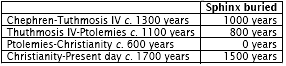
That means that in all this time there has
only been a cumulative total of just over 1000 years in which its
body has been susceptible to wind-erosion; all the rest of the time
it’s been protected from the desert winds by an enormous blanket of
sand.
The point is that if the Sphinx was really built by Khafre in
the Old Kingdom, and if wind erosion was capable of inflicting such
damage on it in so short a time-span, then other Old Kingdom
structures in the area, built out of the same limestone, ought to
show similar weathering. But none do—you know, absolutely
unmistakable Old Kingdom tombs, full of hieroglyphs and
inscriptions—none of them show the same type of weathering as the
Sphinx.’
Indeed, none did.
Professor Robert Schoch, a Boston University
geologist and specialist in rock erosion who had played a key role
in validating West’s evidence, was satisfied as to the reason for
this. The weathering of the Sphinx—and of the walls of its
surrounding rock-hewn enclosure—had not been caused by wind-scouring
at all but by thousands of years of heavy rainfall long ages before
the Old Kingdom came into being.
Having won over his professional peers at the 1992 Convention of the Geological Society of America,4 Schoch went on to explain his
findings to a much wider and more eclectic audience (including
Egyptologists) at the 1992 Annual Meeting of the American
Association for the Advancement of Science (AAAS).
He began by
pointing out to delegates that,
‘the body of the Sphinx and the walls
of the Sphinx ditch are deeply weathered and eroded ... This erosion
is a couple of meters thick in places, at least on the walls. It’s
very deep, it’s very old in my opinion, and it gives a rolling and
undulating profile ...’5
4

‘An abstract of our team’s work was submitted to the Geological
Society of America, and we were invited to present our findings at a
poster session of at the GSA convention in San Diego—the geological
Superbowl. Geologists from all over the world thronged to our booth,
much intrigued. Dozens of experts in fields relevant to our research
offered help and advice. Shown the evidence, some geologists just
laughed, astounded [as Schoch had been initially] that in two
centuries of research, no one, geologist or Egyptologist, had
noticed that the Sphinx had been weathered by water.’ Serpent in the
Sky, p. 229; Mystery of the Sphinx. NBC-TV, 1993. 275 geologists
endorsed Schoch’s findings.
5 AAAS, Annual Meeting 1992, Debate: How
Old is the Sphinx?
Such undulations are easily recognizable to stratigraphers and
palaeontologists as having been caused by ‘precipitation-induced
weathering’.
As Santha Faiia’s photographs of the Sphinx and the
Sphinx enclosure indicate, this weathering takes the distinctive
form of a combination of deep vertical fissures and undulating,
horizontal coves— ‘a classic textbook example,’ in Schoch’s words,
‘of what happens to a limestone structure when you have rain beating
down on it for thousands of years ... It’s clearly rain
precipitation that produced these erosional
features.’6
6 Mystery of the Sphinx.
Wind/sand erosion presents a very different profile of sharp-edged
horizontal channels selectively scoured out from the softer layers
of the affected rock. Under no circumstances can it cause the
vertical fissures particularly visible in the wall of the Sphinx
enclosure.
These could only have been ‘formed by water running down
the wall’,7 the result of rain falling in enormous quantities,
cascading over the slope of the Giza plateau and down into the
Sphinx enclosure below.
‘It picked out the weak spots in the rock,’
Schoch elaborated, ‘and opened them up into these fissures—clear
evidence to me as a geologist that this erosional feature was caused
by rainfall.’8
Although in some places obscured by repair blocks put in place by
numerous restorers over the passing millennia, the same observation
holds true for the scooped-out, undulating, scalloped coves that run
the entire length of the Sphinx’s body. Again, these are
characteristic of precipitation-induced weathering because only long
periods of heavy rainfall beating down on the upper parts of the
immense structure (and cascading over its sides) could have produced
such effects.
Confirmation of this comes from the fact that the
limestone out of which the Sphinx was carved is not uniform in its
composition, but consists of a series of hard and soft layers in
which some of the more durable rocks recede farther than some of the
less durable rocks.9
Such a profile simply could not have been
produced by wind erosion (which would have selectively chiselled out
the softer layers of rock) but,
‘is entirely consistent with
precipitation-induced weathering where you have water, rain water
beating down from above. The rocks higher up are the more durable
ones but they recede back farther than some of the less durable
rocks lower in the section which are more protected.’10
In his summing up at the AAAS meeting, Schoch concluded:
It’s well known that the Sphinx enclosure fills with sand very
quickly, in just a
matter of decades, under the desert conditions of the Sahara. And it
has to be dug
out periodically. And this has been the case since ancient times.
Yet you still get
this dramatic rolling, erosional profile in the Sphinx enclosure ...
Simply put,
therefore, what I’m suggesting is that this rolling profile, these
features seen on
the body and in the Sphinx ditch, hark back to a much earlier period
when there
was more precipitation in the area, and more moisture, more rain on
the Giza
plateau.’11
7 Ibid.
8 Ibid.
9 Ibid.
10 Ibid.
11 AAAS Annual Meeting 1992.
As Schoch admitted, he was not the first geologist to have noticed
the ‘anomalous precipitation-induced weathering features on the core
body
of the Sphinx’.12 He was, however, the first to have become involved
in public debates over the immense historical implications of this
weathering. His attitude was that he preferred to stick to his
geology:
I’ve been told over and over again that the peoples of Egypt, as far
as we know, did not have either the technology or the social
organization to cut out the core body of the Sphinx in pre-dynastic
times ... However, I don’t see it as being my problem as a
geologist. I’m not seeking to shift the burden, but its really up to
the Egyptologists and archaeologists to figure out who carved it.
If
my findings are in conflict with their theory about the rise of
civilization then maybe its time for them to re-evaluate that
theory. I’m not saying that the Sphinx was built by Atlanteans, or
people from Mars, or extra-terrestrials. I’m just following the
science where it leads me, and it leads me to conclude that the
Sphinx was built much earlier than previously thought ...’13
12 Ibid. The relevant geologists include Farouk El Baz, and Roth and
Raffai.
13 Extracts from Mystery of the Sphinx and AAAS meeting.
Legendary civilizations
How much earlier?
John West told us that he and Schoch had ‘a friendly debate going’
about the age of the Sphinx:
‘Schoch puts the date somewhere between
5000 BC and 7000 BC minimum [the epoch of the Neolithic Subpluvial]
mainly by taking the most cautious view allowed by the data to hand.
As a professor of Geology at a big university, he’s almost
constrained to take a conservative view—and it’s true that there
were rains between 7000 BC and 5000 BC.
However, for a variety of
both intuitive and scholarly reasons, I think that the date is much,
much older and that most of the weathering of the Sphinx took place
in the earlier rainy period before 10,000 BC ... Frankly, if it was
as relatively recent as 5000 to 7000 BC, I think we’d probably have
found other evidence of the civilization that carved it. A lot of
evidence from that period has been found in Egypt. There are some
strange anomalies within it, I’ll admit,14 but most of it— the vast
bulk—is really quite rudimentary.’
‘So who built the Sphinx if it wasn’t the pre-dynastic Egyptians?’
‘My conjecture is that the whole riddle is linked in some way to
those legendary civilizations spoken of in all the mythologies of
the world. You know—that there were great catastrophes, that a few
people survived and went wandering around the earth and that a bit
of knowledge was preserved here, a bit there ...
My hunch is that
the Sphinx is linked to all that. If I were asked to place a bet I’d
say that it predates the break-up of the last Ice Age and is
probably older than 10000 BC, perhaps even older than 15,000 BC. My
conviction—actually it’s more than a conviction—is that it’s vastly
old?
14 Under the category of anomalies,
West made specific reference to the bowls carved out of diorite and
other hard stones described in Part VI.
This was a conviction I increasingly shared—and, I reminded myself,
that most nineteenth-century Egyptologists had shared it too.
Nevertheless the Sphinx’s appearance argued against such intuitions
since there was no doubt that its head looked conventionally
pharaonic.
‘If it’s as old as you think it is,’ I now asked John,
‘then how do you explain that the sculptors depicted it wearing the
characteristic nemes head-dress and uraeus of dynastic times?’
‘I’m not bothered about that. In fact, as you know, Egyptologists
contend that the face of the Sphinx resembles the face of Khafre—its
one of the reasons why they claim it must have been built by him.
Schoch and I have looked into this very carefully. We think, from
the proportions of the head relative to the rest of the body, that
it’s been recarved during dynastic times—and that’s why it looks
very dynastic.
But we don’t think it was ever meant to represent Khafre. As part of our ongoing research into these issues we had
Lieutenant Frank Domingo, a forensic artist with the New York Police
Department, come over and do point by point comparisons between the
face of the Sphinx and the face of Cephren’s statue in the Cairo
Museum. His conclusion was that in no way was the Sphinx ever
intended to represent Khafre.
It’s not just a matter of it being a
different face—it’s probably a different race.15 So this is a very
ancient monument that was recarved at a much later date. Originally
it may not even have had a human face. Maybe it started out with a
lion’s face as well as a lion’s body.’
15
'After reviewing my various drawings, schematics and measurements,
my final conclusion concurs with my initial reaction: the two works
represent two separate individuals. The proportions in the frontal
view and especially the angles and facial protrusion in the lateral
views, convinced me that the Sphinx is not Khafre. If the ancient
Egyptians were skilled technicians and capable of duplicating
images, then these two works cannot represent the same individual.'
Frank Domingo, cited in Serpent in the Sky, p. 232. See also AAAS
1992, for Schoch's views on the recarving of the Sphinx's head.
Magellan and the first dinosaur bone
After my own explorations at Giza I was interested to know whether
West’s research had cast doubt on the orthodox dating of any of the
other monuments on the plateau—particularly the so-called Valley
Temple of Khafre.
‘We think there’s quite a lot of stuff that may be older,’ he told
me. ‘Not just the Valley Temple but also the Mortuary Temple up the
hill, probably something to do with the Menkaure complex, maybe even
the Pyramid of Khafre ...’
‘What in the Menkaure complex?’
‘Well, the Mortuary Temple. And actually I’m only using the
conventional attribution of the Pyramids for convenience here ...’
‘OK. So do you think it’s possible that the pyramids are as old as
the Sphinx too?’
‘It’s hard to say. I think something was there where those pyramids
now are—because of the geometry. The Sphinx was part of a
master-plan. And the Khafre Pyramid is maybe the most interesting in
that respect because it was definitely built in two stages. If you
look at it—maybe you’ve noticed—you’ll see that its base consists of
several courses of gigantic blocks similar in style to the blocks of
the core masonry of the Valley Temple.
Superimposed above the base,
the rest of the pyramid is composed of smaller, less precisely
engineered stuff. But when you look at it, knowing what you’re
looking for, you see instantly that it’s built in two separate bits.
I mean I can’t help but feel that the vast blocks on the bottom date
from the earlier period—from the time the Sphinx was built—and that
the second part was added later—but even then not necessarily by Khafre. As you go into this you begin to realize that the more you
learn the more complex everything becomes.
For example, there may
even have been an intermediate civilization, which actually would
correspond to the Egyptian texts. They talk themselves about two
long prior periods. In the first of these Egypt was supposedly ruled
by the gods—the Neteru—and in the second it was ruled by the
Shemsu
Hor, the “Companions of Horus”. So, as I say, the problems just get
more and more complicated. Fortunately, however, the bottom line
stays simple. The bottom line is the Sphinx wasn’t built by Khafre.
The geology proves that it’s a hell of a lot older ...’
‘Nevertheless the Egyptologists won’t accept that it is. One of the
arguments they’ve used against you—Mark Lehner did so—goes something
like this:
“If the Sphinx was made before 10,000 BC then why can’t
you show us the rest of the civilization that built it?”
In other
words, why don’t you have any other evidence to put forward for the
presence of your legendary lost civilization apart from a few
structures on the Giza plateau? What do you say to that?’
‘First off, there are structures outside Giza—for example the
Osireion in Abydos, where you’ve just come from. We think that
amazing edifice may relate to our work on the Sphinx. Even if the
Osireion didn’t exist, however, the absence of other evidence
wouldn’t worry me.
I mean, to make a big deal out of the fact that
further confirmatory evidence hasn’t been found yet and to use this
to try to scuttle the arguments for an older Sphinx is completely
illogical. Analogously it’s like saying to Magellan ...
“Where are
the other guys who’ve sailed round the world? Of course it’s still
flat.”
Or in 1838 when the first dinosaur bone was found they would
have said,
“Of course there’s no such thing as a giant extinct
animal. Where’s the rest of the skeletons? They’ve only found one
bone.”
But once a few people began to realize that this bone could
only be from an extinct animal, within twenty years the museums of
the world were filled up with complete dinosaur skeletons. So it’s
sort of like that. Nobody’s thought to look in the right places.
I’m
absolutely certain that other evidence will be found once a few
people start looking in the right places—along the banks of the
ancient Nile, for example, which is miles from the present Nile, or
even at the bottom of the Mediterranean, which was dry during the
last Ice Age.’
The problem of transmission
I asked John West why he thought that Egyptologists and
archaeologists were so unwilling to consider that the Sphinx might
be a clue to the existence of a forgotten episode in human history.
‘The reason, I think, is that they’re quite fixed in their ideas
about the linear evolution of civilization. They find it hard to
come to terms with the notion that there might have been people,
more than 12,000 years ago, who were more sophisticated than we are
today ...
The Sphinx, and the geology which proves its antiquity,
and the fact that the technology that was involved in making it is
in many ways almost beyond our own capacities, contradicts the
belief that civilization and technology have evolved in a
straightforward, linear way ... Because even with the best modern
technology we almost couldn’t carry out the various tasks that were
involved in the project.
The Sphinx itself, that’s not such a
staggering feat. I mean if you get enough sculptors to cut the stone
away they could carve a statue a mile long. The technology was
involved in taking the stones, quarrying the stones, to free the
Sphinx from its bedrock and then in moving those stones and using
them to build the Valley Temple a couple of hundred feet away ...’
This was news to me:
‘You mean that the 200-ton blocks in the Valley
Temple walls were quarried right out of the Sphinx enclosure?’
‘Yes, no doubt about it. Geologically they’re from the identical
member of rock. They were quarried out, moved over to the site of
the Temple— God knows how—and erected into forty-foot-high
walls—again God knows how. I’m talking about the huge limestone core
blocks, not the granite facing. I think that the granite was added
much later, quite possibly by Khafre.
But if you look at the
limestone core blocks you’ll see that they bear the marks of exactly
the same kind of precipitation-induced weathering that are found on
the Sphinx. So the Sphinx and the core structure of the Valley
Temple were made at the same time by the same people—whoever they
may have been.’
‘And do you think that those people and the later dynastic Egyptians
were connected to each other in some way? In
Serpent in the Sky you
suggested that a legacy must have been passed on.’
‘It’s still just a suggestion. All that I know for sure on the basis
of our work on the Sphinx is that a very, very high, sophisticated
civilization capable of undertaking construction projects on a grand
scale was present in Egypt in the very distant past. Then there was
a lot of rain.
Then, thousands of years later, in the same place, pharaonic
civilization popped up already fully formed, apparently out of
nowhere, with all its knowledge complete. That much we can be
certain of. But whether or not the knowledge that Ancient Egypt
possessed was the same as the knowledge that produced the Sphinx I
really can’t say.’
‘How about this,’ I speculated: ‘The civilization that produced the
Sphinx wasn’t based here, at least not originally ... It wasn’t in
Egypt. It put the Sphinx here as some sort of a marker or outpost
...’
‘Perfectly possible. Could be that the Sphinx for that civilization
was like, let’s say, what Abu Simbel [in Nubia] was for dynastic
Egypt.’
‘Then that civilization came to an end, was extinguished by some
sort of massive catastrophe, and that’s when the legacy of high
knowledge was handed on ... Because they had the Sphinx here they
knew about Egypt, they knew this place, they knew this country, they
had a connection here. Maybe people survived the ending of that
civilization. Maybe they came here. ... Does that work for you?’
‘Well, it’s a possibility. Again, going back into the mythologies
and legends of the world, many of them tell of such a catastrophe
and of the few people—the Noah story that’s prevalent through
endless civilizations—who somehow or other retained and passed on
knowledge.
The big problem with all this, from my point of view, is
the transmission process: how exactly the knowledge does get handed
on during the thousands and thousands of years between the
construction of the Sphinx and the flowering of dynastic Egypt.
Theoretically you’re sort of stuck—aren’t you?—with this vast period
in which the knowledge has to be transmitted. This is not easy to
slough off. On the other hand we do know that those legends we’re
referring to were passed on word for word over countless
generations.
And in fact oral transmission is a much surer means of
transmission than written transmission, because the language may
change but as long as whoever’s telling the story tells it true in
whatever the language of the time is ... it surfaces some 5000 years
later in its original form. So maybe there are ways—in secret
societies and religious cults, or through mythology, for
example—that the knowledge could have been preserved and passed on
before flowering again.
The point, I think, with problems as complex
and important as these, is simply not to dismiss any possibilities,
no matter how outrageous they may at first seem, without
investigating them very, very thoroughly ...’
Second opinion
John West was in Luxor, leading a study group on Egypt’s sacred
sites. Early the next day he and his students went south to Aswan
and Abu Simbel. Santha and I journeyed north again, back towards
Giza and the mysteries of the Sphinx and the pyramids. We were to
meet there with the archaeo-astronomer Robert Bauval.
As we shall
see, his stellar correlations provided startling independent
corroboration for the geological evidence of Giza’s vast antiquity.
Back to
Contents
Chapter 48 -
Earth Measurers
Follow these instructions carefully:
Draw two parallel straight lines vertically down a sheet of paper,
about seven inches long and a bit under three inches apart. Draw a
third line, also vertical, also parallel and of equal length,
exactly mid-way between the first two. Write the letter ‘S’—for
‘South’—at the top end of your diagram (the end farthest away from
you), and the letter ‘N’ for ‘North’ at the bottom end. Add the
letters ‘E’ for ‘East’ and ‘W for ‘West’ in their appropriate
positions at either side of the diagram, to your left for East and
to your right for West.
What you are looking at are the outlines of a geometrical map of
Egypt incorporating a perspective very different from our own (where
‘North’ is always equated with ‘Up’). This map where ‘Up’ is ‘South’
seems to have been worked out an enormously long time ago by
cartographers with a scientific understanding of the shape and size
of our planet.
To complete the map you should now mark a dot on the central of the
three parallel lines about an inch to the south of (‘up’ from) the
northern end of the diagram. Then draw two more lines diagonally
down from this point, respectively to the north-east and north-west,
until they reach the northern ends of the two outermost parallel
lines. Finally link those parallel lines directly with horizontal
lines running east to west at the northern and southern ends of the
diagram.
The shape produced is a meridional rectangle (oriented north-south).
This rectangle is seven inches long by just under three inches wide
and has a triangle demarcated at its northern (lower) end. The
triangle represents the Nile Delta and the dot at the apex of the
triangle represents the apex of the Delta—a point on the ground at
30° 06’ north and 31° 14’ east, very close to the location of the
Great Pyramid.
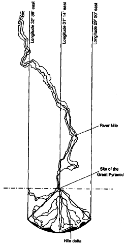
Map showing the geometric conception of Egypt, with the Great
Pyramid at the apex of the Nile delta.
The Egyptians traditionally
thought of south as ‘up’.
Geodetic marker
Whatever else it may be, it has long been understood by
mathematicians and geographers that the Great Pyramid serves the
function of a geodetic marker (geodetics being the branch of science
concerned with determining the exact position of geographical points
and the shape and size of the earth1).
This realization first dawned
in the late eighteenth century when the armies of revolutionary
France, led by Napoleon Bonaparte, invaded Egypt.
Bonaparte, who had
cultivated a deep interest in the enigmas of the pyramids, brought
with him a large number of scholars, 175 in all, including several
‘greybeards’ gathered from various universities who were reputed to
have acquired ‘a profound knowledge of Egyptian antiquities’, and,
more usefully, a group of mathematicians, cartographers and
surveyors.2
One of the tasks the savants were set, after the conquest was
completed, was to draw up detailed maps of Egypt. In the process of
doing this they discovered that the Great Pyramid was perfectly
aligned to true north—and of course to the south, east and west as
well, as we saw in Part VI. This meant that the mysterious structure
made an excellent reference and triangulation point, and a decision
was therefore taken to use the meridian passing through its apex as
the base-line for all other measurements and orientations.
The team
then proceeded to produce the first accurate maps of Egypt drawn up
in the modern age. When they had finished, they were intrigued to
note that the Great Pyramid’s meridian sliced the Nile Delta region
into two equal halves. They also found that if the diagonals running
from the pyramid’s apex to its north-eastern and north-western
corners were extended (forming lines on the map running north-east
and northwest until they reached the Mediterranean), the triangle
thus formed would neatly encapsulate the entire Delta area.3
Let us now return to our map, which also incorporates a triangle
representing the Delta. Its other main components are the three
parallel meridians. The eastern meridian is at longitude 32° 38’
east—the official eastern border of Ancient Egypt from the beginning
of dynastic times. The western meridian is at longitude 29° 50’
east, the official western border of ancient Egypt. The central
meridian is at longitude 31° 14’ east, exactly midway between the
other two (1° 24’ away from each).4
What we now have is a representation of a strip on the surface of
planet earth that is exactly 2° 48’ wide. How long is this strip?
Ancient Egypt’s ‘official’ northern and southern borders (which bore
no more relationship to settlement patterns than the official
eastern and western boundaries) are marked by the horizontal lines
at the top and bottom of the map and are located respectively at 31°
06’ north and 24° 06’ north.5
The northern border, 31° 06’ north, joins the two outer ends of the
estuary of the Nile.
1 Collins English Dictionary, p. 608.
2
Secrets of the Great Pyramid, p. 38. Much of the material in this
chapter is based directly on the work of Peter Tompkins and of
Professor Livio Catullo Stecchini.
3 Ibid., p. 46.
4 Ibid., p. 181.
5 Ibid., p. 299.
6 Ibid., pp. 179-81.
The southern border, 24° 06’ N, marks the precise latitude of the
island
of Elephantine at Aswan (Seyne) where an important astronomical and
solar observatory was located throughout known Egyptian history.6 It
seems, that this archaic land, sacred since time began—the creation
and habitation of the gods—was originally conceived of as a
geometric construct exactly seven terrestrial degrees in length.
Within this construct, the Great Pyramid appears to have been
carefully sited as a geodetic marker for the apex of the Delta. The
latter, which we have indicated on our map, is located at 30° 06’ N
31° 14’ E—a point in the middle of the Nile at the northern edge of
modern Cairo. Meanwhile the pyramid stands at latitude of 30°N
(corrected for atmospheric refraction) and at longitude 31° 09’ E,
an error of just a few minutes of terrestrial arc to the south and
west. This ‘error’, however, does not appear to have resulted from
sloppiness or inaccuracy on the part of the pyramid builders.
On the
contrary, a close look at the topography of the area suggests that
the explanation should be sought in the need to find a site suitable
for all the astronomical observations that had to be taken for
accurate setting-out, and with a sufficiently stable geological
structure on which to park, for ever, a six-million-ton monument
almost 500 feet high with a footprint of over thirteen acres.
The Giza plateau fits the bill on all counts: close to the apex of
the Delta, elevated above the Valley of the Nile, and equipped with
an excellent foundation of solid limestone bedrock.
Doing things by degrees
We were driving north from Luxor to Giza in the back of Mohamed
Walilli’s Peugeot 504—a journey of just over 4 degrees of longitude,
i.e., from 25° 42’ N, to the 30th parallel. Between Asiut and El
Minya, a corridor of conflict in recent months between Islamic
extremists and Egyptian government forces, we were provided with an
armed escort of soldiers, one of whom wore plain clothes and sat in
the passenger seat beside Mohamed fondling an automatic pistol.
The
others, about a dozen men armed with AK47 assault rifles, were
distributed equally between two pick-up trucks which sandwiched us
front and rear.
‘Dangerous people live here,’ Mohamed had confided out of the corner
of his mouth when we had been stopped at a road-block in Asiut and
ordered to wait for our escort. Now, although obviously rattled at
being obliged to match the high speed of the escorting vehicles, he
seemed to relish the kudos of being part of an impressive convoy,
lights flashing and sirens wailing, weaving in and out of the slower
traffic on the main highway from upper to lower Egypt.
I looked out of the car window for a while at the unchanging
spectacle of the Nile, at its fertile green banks and the red haze
of the deserts a few
miles away to east and west. This was Egypt, the real organic Egypt
of today and yesterday, which overlapped (but spread out far beyond)
the strange ‘official’ Egypt of the map described, a rectangular
fiction exactly seven terrestrial degrees in length.
In the nineteenth century the renowned Egyptologist Ludwig Borchardt
expressed what is still the conventional wisdom of his colleagues
when he remarked, ‘One must absolutely exclude the possibility that
the ancients may have measured by degrees.’7
This was a judgment
that seemed increasingly unlikely to be tenable. Whoever they may
have been, it was obvious that the original planners and architects
of the Giza necropolis had belonged to a civilization which knew the
earth to be a sphere, knew its dimensions almost as well as we do
ourselves, and had divided it into 360 degrees, just as we do today.
The proof of this lay in the creation of a symbolic official
‘country’ exactly seven terrestrial degrees in length, and in the
admirably geodetic location and orientation to the cardinal points
of the Great Pyramid. Equally persuasive was the fact, already
touched on in Chapter Twenty-three, that the perimeter of the
pyramid’s base stood in the relationship 2pi to its height and that
the entire monument seemed to have been designed to serve as a
map-projection—on a scale of 1:43,200—of the northern hemisphere of
our planet:
The Great Pyramid was a projection on four triangular surfaces. The
apex represented the pole and the perimeter represented the equator.
This is the reason why the perimeter is in relation 2pi to the
height.8
7 Cited in Ibid., p. 333.
8 See Chapter Twenty-three, and Stecchini
in Secrets of the Great Pyramid, p. 378.
The Pyramid/Earth ratio
We have demonstrated the use of pi in the Pyramid9 and need not go
into this matter again; besides, the existence of the pi
relationship, though interpreted as accidental by orthodox scholars,
is not contested by them.10 But are we seriously supposed to accept
that the monument could also be a representation of the northern
hemisphere of the earth projected on flat surfaces at a scale of
1:43,200?
Let us remind ourselves of the figures.
According to the best modern estimates, based on satellite
observations, the equatorial circumference of the earth is 24,902.45
miles and its polar radius is 3949.921 miles.11 The perimeter of the
Great Pyramid’s base is 3023.16 feet and its height is 481.3949
feet.12
9 See Chapter Twenty-three.
10 Accepted, for example, by Edwards, Petrie, Baines and Malek, and
so on.
11 Encyclopaedia Britannica, 1991, 27:530.
12 The Pyramids of Egypt,
p. 87.
The
scaling-down, as it turns out, is not absolutely exact, but it is
very near. Moreover, when we remember the bulge at the earth’s
equator (our planet being an oblate spheroid rather than a perfect
sphere), the results achieved by the pyramid builders seem even
closer to 1:43,200.
How close?
If we take the earth’s equatorial circumference, 24,902.45 miles,
and scale it down (divide it) by 43,200 we get a result of 0.5764 of
a mile. There are 5280 feet in a mile. The next step, therefore, is
to multiply 0.5764 by 5280, which produces a figure of 3043.39 feet.
The earth’s equatorial circumference scaled down 43,200 times is
therefore 3,043.39 feet. By comparison, as we have seen, the
perimeter of the Great Pyramid’s base is 3,023.16 feet. This
represents an ‘error’ of only 20 feet—or about three-quarters of 1
per cent.
Given the razor-sharp accuracy of the pyramid builders,
however (who normally worked to even finer tolerances), the error is
less likely to have resulted from mistakes in the construction of
the giant monument than in an underestimation of our planet’s true
circumference by just 163 miles, probably caused in part by failure
to take account of the equatorial bulge.
Let us now consider the earth’s polar radius of 3949.921 miles. If
we scale it down 43,200 times we get 0.0914 of a mile: 482.59 feet.
The earth’s polar radius scaled down 43,200 times is therefore
482.59 feet. By comparison the Great Pyramid’s height is 481.3949
feet—just a foot less than the ideal figure, an error of barely
one-fifth of one per cent.
As near as makes no difference, therefore, the perimeter of the
Great Pyramid’s base is indeed 1:43,200 of the equatorial
circumference of the earth. And as near as makes no difference, the
height of the Great Pyramid above that base is indeed 1:43,200 of
the polar radius of the earth.
In other words, during all the
centuries of darkness experienced by Western civilization when
knowledge of our planet’s dimensions was lost to us, all we ever
needed to do to rediscover that knowledge was to measure the height
and base perimeter of the Great Pyramid and multiply by 43,200!
How likely is this to be an ‘accident’?
The commonsense answer is ‘not very likely at all,’ since it should
be obvious to any reasonable person that what we are looking at
could only be the result of a deliberate and carefully calculated
planning decision. Commonsense, however, has never been a faculty
held in high esteem by Egyptologists, and it is therefore necessary
to ask whether there is anything else in the data which might
confirm that the ratio of 143,200 is a purposeful expression of
intelligence and knowledge, rather than some numerical fluke.
The ratio itself seems to provide that confirmation, for the simple
reason that 43,200 is not a random number (like, say, 45,000 or
47,000, or 50,500, or 38,800). On the contrary it is one of a series
of numbers, and multiples of those numbers, which relate to the
phenomenon of precession of the equinoxes, and which have become
embedded in archaic myths all around the world.
As the reader can
confirm by glancing back at Part V the basic numerals of the
Pyramid/Earth ratio crop up again and again in those myths,
sometimes directly as 43,200 sometimes as 432, as 4320, as 432,000,
as 4,320,000, and so on.
What we appear to be confronted by are two remarkable propositions,
back-to-back, as though designed to reinforce one another. It is
surely remarkable enough that the Great Pyramid should be able to
function as an accurate scale-model of the northern hemisphere of
planet earth. But it is even more remarkable that the scale involved
should incorporate numbers relating precisely to one of the key
planetary mechanisms of the earth.
This is the fixed and apparently
eternal precession of its axis of rotation around the pole of the
ecliptic, a phenomenon which causes the vernal point to migrate
around the band of the zodiac at the rate of one degree every 72
years, and 30 degrees (one complete zodiacal constellation) every
2160 years. Precession through two zodiacal constellations, or 60
degrees along the ecliptic, takes 4320 years.13
13 See Part V.
The constant repetition of these precessional numbers in ancient
myths could, perhaps, be a coincidence. Viewed in isolation, the
appearance of the precessional number 43,200 in the pyramid/earth
ratio might also be a coincidence (although the odds against this
must be astronomical). But when we find precessional numbers in both
these very different media— the ancient myths and the ancient
monument—it really does strain credulity to suppose that coincidence
is all that is involved here.
Moreover, just as the Teutonic myth of
Valhalla’s walls leads us to the precessional number 432,000 by
inviting us to calculate the warriors who ‘go to war with the Wolf
(500 plus 40 multiplied by 800, as saw in Chapter Thirty-three), so
the Great Pyramid leads us to the precessional number 43,200 by
demonstrating through the pi relationship that it might be a
scale-model part of the earth and then by inviting us to calculate
that scale.
Matching fingerprints?
At El Minya our escort vehicles left us, though the plain-clothes
soldier in the front seat stayed with us until Cairo. We paused for
a late lunch of bread and felafel in a boisterous, noisy village,
then motored north again.
Throughout all this, my thoughts remained focused on the Great
Pyramid. Obviously it was not an accident that so immense and
conspicuous a structure should occupy a key geographic and geodetic
location in a part of the world that appeared, bizarrely, to have
been conceived of and ‘geometrized’ as a rectangular, symbolic
construct exactly seven terrestrial degrees in length. But it was
the pyramid’s other
function as a three-dimensional map projection of the northern
hemisphere that particularly interested me because it suggested a
‘match’ with the ancient but advanced maps of the world described in
Part I.
Those maps, which made use of spherical trigonometry and a
range of sophisticated projections, had been claimed by Professor
Charles Hapgood to provide tangible, documentary evidence that an
advanced civilization with a comprehensive knowledge of the globe
must have flourished during the last Ice Age. Now here was the Great
Pyramid proving to have a cartographic function vis-à-vis the
northern hemisphere and also incorporating a sophisticated
projection. As one expert explained:
Each flat face of the Pyramid was designed to represent one curved
quarter of the northern hemisphere, or spherical quadrant of 90
degrees. To project a spherical quadrant on to a flat triangle
correctly, the arc, or base, of the quadrant must be the same length
as the base of the triangle, and both must have the same height.
This happens to be the case only with a cross-section or meridian
bisection of the Great Pyramid, whose slope angle gives the pi
relation between height and base 14
...
Was it possible that surviving copies and compilations of ancient
maps— like
the Piri Reis Map, for example—might in some cases go
back to source documents produced by the same culture that
skillfully incorporated its knowledge of the globe into the
dimensions of the Great Pyramid (and indeed into the carefully
geometrized dimensions of Ancient Egypt itself)?
I could hardly forget that Charles Hapgood and his team had spent
months trying to work out where the original projection of the Piri
Reis Map had been centered. The answer they finally obtained was
Egypt and specifically Seyne (Aswan) in upper Egypt15—where, as we
have seen, an important astronomical observatory was situated at
latitude 24° 06’ N, the official southern border.
14 Secrets of the Great Pyramid, p. 189.
15 Maps of the Ancient Sea
Kings, p. 17ff.
16 See, for example, The Shape of the World, p. 23.
Needless to say, precise astronomical observations would have been
essential for calculations of the circumference of the earth and of
latitude positions.16 But for how long before the historical period
had the Ancient Egyptians and their ancestors been making such
observations? And had they indeed learned this skill, as they stated
forthrightly in their traditions, from the gods who had once walked
among them?
Navigators in the Boat of Millions of Years
The god believed by the Ancient Egyptians to have taught the
principles of astronomy to their ancestors was Thoth:
‘He who
reckons in heaven,
the counter of the stars, the enumerator of the earth and of what is
therein, and the measurer of the earth.’17
Normally depicted as a man wearing an ibis mask, Thoth was a leading
member of the elite company of First Time deities who dominated
religious life in Ancient Egypt from the beginning to the end of its
civilization. These were the great gods, the Neteru. Although they
were believed in one sense to be self-created, it was also openly
acknowledged and understood that they had a special connection of
some kind with another land—a fabulous and far-off country referred
to in the ancient texts as Ta-Neteru, the ‘land of the gods’.18
Ta-Neteru was thought to have had a definite earthly location a very
long way south of Ancient Egypt—seas and oceans away—farther even
than the spice country of Punt (which probably lay along East
Africa’s Somali coast).19 To confuse matters, however, Punt was also
spoken of sometimes as the ‘Divine Land’, or ‘God’s Land’, and was
the source of the sweet-smelling frankincense and myrrh especially favoured by the gods.20
Another mythical paradise was also linked to the Neteru—an ‘abode of
the blessed’, where the best of humans were sometimes taken—which
was believed to be ‘situated away beyond a large expanse of water’.
As Wallis Budge observed in his important study, Osiris and the
Egyptian Resurrection,
‘the Egyptians believed that this land could
only be reached by means of a boat, or by the personal help of the
gods who were thought to transport their favourites thither ...’21
Those lucky enough to gain entry would find themselves in a magical
garden consisting of ‘islands, interconnected by canals filled with
running water which caused them to be always green and fertile’.22
On the islands in this garden,
‘the wheat grew to a height of five
cubits, the ears being two cubits long and the stalks three, and the
barley grew to a height of seven cubits, the ears being three cubits
long and the stalks four.’23
17 The Gods of the Egyptians, volume I, p. 400.
18 Ibid., volume I,
p. 443; volume II, pp. 7, 287.
19
Ibid., volume II, p. 7, where the deity Amen-Ra is addressed in a
hymn: ‘The gods love the smell of thee when thou comest from Punt,
thou eldest-born of the dew, who comest from the Divine Land
(Ta-Neteru).’ See also volume II, p. 287. Punt is thought by many
scholars to have been located on the Somali coast of East Africa
where the trees that produce frankincense and myrrh (‘the food of
the gods’) are still grown today.
20 Ibid.
21
Osiris and the Egyptian Resurrection, volume I, p. 98; Pyramid Texts
of Pepi I, Mer-en-Rah and Pepi II, translated in Ibid., volume II,
p. 316, where the maritime connections of the land of the blessed
are made clear.
22 Ibid., volume I, p. 97.
23 Ibid., pp. 97-8.
24
Ibid., volume II, p. 307.
-
Was it from a land such as this,, superbly irrigated and
scientifically farmed, that the agriculture bringer Osiris, whose
title was ‘President of the Land of the South’,24 had voyaged to
Egypt at the dawn of the First
Time?
-
And was it from a land such as this, accessible only by boat,
that ibis-masked Thoth had also made his way, crossing seas and
oceans to deliver the priceless gifts of astronomy and
earth-measurement to the primitive inhabitants of the prehistoric
Nile Valley?
Whatever the truth behind the tradition, Thoth was remembered and
revered by the Ancient Egyptians as the inventor of mathematics,
astronomy and engineering.25
‘It was his will and power’, according
to Wallis Budge, ‘that were believed to keep the forces of heaven
and earth in equilibrium. It was his great skill in celestial
mathematics which made proper use of the laws upon which the
foundation and maintenance of the universe rested.’26
Thoth was also
credited with teaching the ancestral Egyptians the skills of
geometry and land-surveying, medicine and botany. He was believed to
have been the inventor ‘of figures, of the letters of the alphabet,
and of the arts of reading and writing’.27 He was the
Great Lord of
Magic’28 who could move objects with the power of his voice, ‘the
author of every work on every branch of knowledge, both human and
divine’.29
It was to the teachings of Thoth—which they guarded jealously in
their temples and claimed to have been handed down from generation
to generation in the form of forty-two books of instruction30—that
the Ancient Egyptians ascribed their world-renowned wisdom and
knowledge of the skies. This knowledge was spoken of almost in awe,
by the classical commentators who visited Egypt from the fifth
century BC onwards.
Herodotus, the earliest of these travellers, noted:
The Egyptians were the first to discover the solar year, and to
portion out its course into twelve parts ... It was observation of the course of the
stars which led them to adopt this division ...31
Plato (fourth century BC) reported that the Egyptians had observed
the stars ‘for ten thousand years’.32
And later, in the first
century BC, Diodorus Siculus left this more detailed account:
The positions and arrangements of the stars as well as their motions
have always been the subject of careful observation among the
Egyptians ... From ancient times to this day they have preserved the
records concerning each of these stars over an incredible number of
years ...33
25 Veronica Ions, Egyptian Mythology, Newnes Books, London, 1986, p.
84.
26 The Gods of the Egyptians, volume I, pp. 407-8.
27 Ibid.,
volume I, p. 414.
28 Egyptian Mythology, p. 85.
29 The Gods of the Egyptians, volume
I, p. 414.
30 Ibid., pp 414-15.
31 The History, 2:4.
32
Reported in E. M. Antoniadi, L’Astronomie egyptienne, Paris, 1934,
pp. 3-4; see also Schwaller, p. 279.
33 Diodorus Siculus, volume I,
pp. 279-80.
Why should the Ancient Egyptians have cultivated an almost
obsessional interest in the long-term observation of the stars, and
why in particular should they have kept records of their movements
‘over an incredible number of years’? Such detailed observations
would not have been necessary if their only interest, as a number of
scholars have seriously suggested, had been agricultural (the need
to predict the seasons, which any country-born person can do). There
must have been some other purpose.
Moreover, how did the Ancient Egyptians get started on astronomy in
the first place? It is not an obvious hobby for a valley-dwelling
landlocked people to develop on their own initiative. Perhaps we
should take more seriously the explanation they themselves offer:
that their ancestors were taught the study of the stars by a god. We
might also pay closer attention to the many unmistakably maritime
references in the Pyramid Texts.34
And there could be important new
inferences to draw from ancient Egyptian religious art in which the
gods are shown travelling in beautiful, high-prowed, streamlined
boats, built to the same advanced ocean-going specifications as the
pyramid boats at Giza and the mysterious fleet moored in the desert
sands at Abydos.
34 The Ancient Egyptian Pyramid Texts, for example pp. 78, 170, 171,
290.
Landlocked people do not as rule become astronomers; seafaring
people do. Is it not possible that the maritime iconography of the
Ancient Egyptians, the design of their ships, and also their
splendid obsession with observing the stars, could have been part of
an inheritance passed on to their ancestors by an unidentified
seafaring, navigating race, in remote prehistory? It is really only
such an archaic race, such a forgotten maritime civilization, that
could have left its fingerprints behind in the form of maps which
accurately depict the world as it looked before the end of the last
Ice Age.
It is really only such a civilization, steering its course
by the stars ‘for ten thousand years’ that could have observed and
accurately timed the phenomenon of equinoctial precession with the
exactitude attested in the ancient myths. And, although
hypothetical, it is only such a civilization that could have
measured the earth with sufficient precision to have arrived at the
dimensions scaled down in the Great Pyramid.
The signature of a distant date
It was almost midnight by the time that we reached Giza. We checked
into the Siag, a hotel with an excellent pyramid view, and sat out
on our balcony as the three stars of Orion’s belt tracked slowly
across the southern heavens.
It was the disposition of these three stars, as archaeo-astronomer
Robert Bauval had recently demonstrated, that served as the
celestial
template for the site-plan of the three Giza pyramids. This, in
itself, was a remarkable discovery, suggesting a far higher level of
observational astronomy, and of surveying and setting-out skills,
than scholars had attributed to the Ancient Egyptians.
Even more
remarkable, however—and the reason that I had arranged to meet him
at Giza the next morning— was Bauval’s contention that the pattern
traced out on the ground (in almost fifteen million tons of
perfectly dressed stone) matched exactly the pattern in the sky
during the epoch of 10,450 BC.
If Bauval was correct, the pyramids had been devised, using the
changes precession effects in the positions of the stars, as the
permanent architectural signature of the eleventh millennium BC.
Back to
Contents
or
Continue to Chapter 49
→
|