|
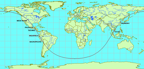
14.3 - A SECOND ALIGNMENT WITH MACHUPICCHU
Machupicchu, Ollantaytambo,
Saqsaywaman and
Cusco are aligned with
Ingapirca; Tazumal, Mixco Viejo,
Bonampak, Palenque, and La Venta;
Mesa Verde and Chaco Canyon;
Shanghai; and the partially submerged ancient capital
city of Oc-Eo in the Mekong Delta.
This alignment also crosses over the source of the Amazon River;
the mouth of the Parana River at Buenos Aires; the
mouth of the
Mekong River at Oc-Eo; the mouth of the Xi river
at Macau; the mouth of the
Yangtze River at Shanghai; and the mouth of the
Rio Grande River at Matamoros.
|
|
Latitude
|
Longitude
|
Distance To Axis Point:
31° 50' S 170° 40' W
|
Distance To:
Great
Circle
|
|
Cusco
|
13° 31' S
|
71° 59' W
|
6229 miles
|
14 miles
|
|
Ollantaytambo
|
13° 15' S
|
72° 16' W
|
6223 miles
|
8 miles
|
|
Machupicchu
|
13° 06' S
|
72° 35' W
|
6214 miles
|
1 miles
|
|
Ingapirca
|
2° 31'S
|
78° 49'W
|
6239 miles
|
24 miles
|
|
Tazumal
|
13° 59' N
|
89° 33' W
|
6224 miles
|
9 miles
|
|
Mixco Viejo
|
14° 58' N
|
90° 32' W
|
6207 miles
|
8 miles
|
|
Bonampak
|
16° 52' N
|
92° 15' W
|
6237 miles
|
22 miles
|
|
Palenque
|
17° 32' N
|
91° 58' W
|
6216 miles
|
1 mile
|
|
La Venta
|
18° 00' N
|
92° 55' W
|
6190 miles
|
25 miles
|
|
Chaco Canyon
|
36° 03' N
|
107° 59' W
|
6203 miles
|
12 miles
|
|
Mesa Verde
|
37° 09' N
|
108° 31' W
|
6215 miles
|
0 miles
|
|
Shanghai
|
31° 14' N
|
121° 27' E
|
6222 miles
|
7 miles
|
|
Oc-Eo
|
10° 01' N
|
105° 06' E
|
6249 miles
|
34 miles
|

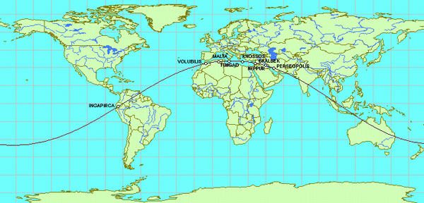
14.4 - A SECOND ALIGNMENT WITH PERSEOPOLIS
Perseopolis is aligned with the ancient
Sumarian/Babylonian/Assyrian
center at Nippur; Baalbek and the ancient
Phoenician city of
Byblos; the ancient cities of Palaikastro
and Knossos on the Island Of Crete; the Island of
Malta; the North African sites of ancient Roman construction at
Volubilis and Timgad; and the Incan and
Pre-Incan fortress, temples and astronomical observatories at
Ingapirca.
|
|
Latitude
|
Longitude
|
Distance To Axis Point:
54° 05'N 165° 20'W
|
Distance To:
Great
Circle
|
|
Ingapirca
|
2° 31' S
|
78° 49' W
|
6,221 miles
|
6 miles
|
|
Volubilis
|
34° 51' N
|
5° 33' W
|
6,226 miles
|
11 miles
|
|
Timgad
|
35° 27' N
|
6° 38' E
|
6,233 miles
|
18 miles
|
|
Malta
|
35° 53' N
|
14° 31' E
|
6,215 miles
|
0 miles
|
|
Knossos
|
35° 17' N
|
25° 09' E
|
6,228 miles
|
13 miles
|
|
Palaikastro
|
35 14' N
|
26° 16' E
|
6,227 miles
|
12 miles
|
|
Byblos
|
34 08' N
|
35 38' E
|
6,215 miles
|
0 miles
|
|
Baalbek
|
34° N
|
36° 13' E
|
6,217 miles
|
2 miles
|
|
Nippur
|
32 05' N
|
45 10' E
|
6,212 miles
|
3 miles
|
|
Perseopolis
|
29° 50' N
|
52° 52' E
|
6,208 miles
|
7 miles
|
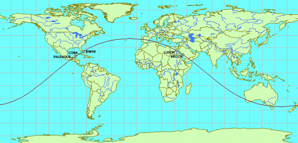
14.5 - A SECOND ALIGNMENT WITH LUXOR AND PALENQUE
In Global Sacred Alignments, Terry Walsh diagrams
the alignment of
Palenque, Bimini, Luxor and
Mecca. The large Mayan city of Coba, site
of the tallest Mayan pyramid, is also on this alignment.
|
|
Latitude
|
Longitude
|
Distance To Axis Point:
49° 52' S 23° 45' W
|
Distance To:
Great
Circle
|
|
Palenque
|
17° 32' N
|
91°58'W
|
6,222 miles
|
7 miles
|
|
Coba
|
20° 31'N
|
87° 39' W
|
6,218 miles
|
3 miles
|
|
Bimini
|
25° 46' N
|
79° 15' W
|
6,213 miles
|
2 miles
|
|
Luxor
|
25° 43' N
|
32° 35' E
|
6,211 miles
|
4 miles
|
|
Mecca
|
21° 26' N
|
39° 53' E
|
6,221 miles
|
6 miles
|
14.6 - A CIRCLE WITH A CIRCUMFERENCE EQUAL TO THE 15TH PARALLELS
The Great Pyramid, Easter Island,
Palenque,
Dzibilchatun, Stonehenge,
the Acropolis, and what remains of the Island of
Thera are all equally distant from a point in the South
Atlantic Ocean located at 20°55'S 26°10'W.
A circle drawn around 20°55'S 26°10'W with a great circle
radius of 5,180 miles crosses over all of these sites. It is
interesting to note that the distance from the North Pole to 15°
north latitude is also exactly 5,180 miles. Thus, the circumference
of this circle is the same as the circumference of the 15th
parallels.
Northwest of the Acropolis, Delphi is close to the
circle. Northwest of the Great Pyramid, the ancient capitals of
Alexandria and
Sais in Egypt are close to the circle. Several pyramids
and other sites of ancient construction are south-south-east of the
Great Pyramid and close to the circle. Likewise, a number of
Mayan and Olmec sites between Palenque and
Dzibilchitun on the Yucatan Peninsula are close to the
circle. Similarly, in addition to Stonehenge, a number
of megalithic sites in Southern England, Southern Ireland and
Northern France are close to the circle.
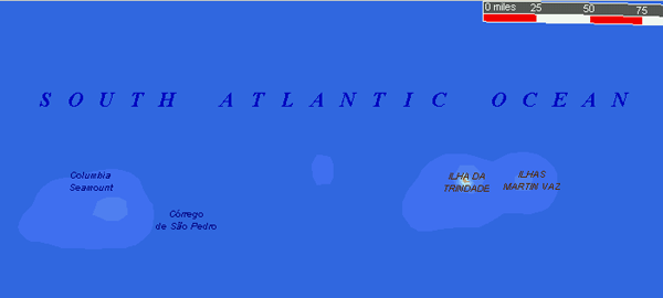
Tiny Ilhas Martin Vaz, the last link in an old island
chain running east from the coast of Brazil, is located at 20°28'S
28°51'W, just over two degrees west of 20°55'S 26°10'W. Ilhas
de Trindade is the next to last island in the chain, located
at 20°30'S 29°19'W. The British astronomer, Richard Halley,
once took over Trindade on behalf of the British Crown. Trindade is
famous for a UFO sighting that was photographed in
1958. In addition to the two locations that were suggested as
possible sites for the submerged island of Atlantis in
A New Look at an Old Design, another good place to look is just
East of Ilhas Martin Vaz, at
20°55'S 26°10'W.
|
|
Latitude
|
Longitude
|
Distance To Axis Point:
20°55'S 26°10'W
|
Distance To:
Great
Circle
|
|
The Great Pyramid
|
29°59'S
|
31°09'E
|
5,175 miles
|
5 miles
|
|
Easter Island
|
27°04S
|
109°22'W
|
5,182 miles
|
2 miles
|
|
Palenque
|
17°32'N
|
91°58'W
|
5,185 miles
|
5 miles
|
|
Dzibilchatun
|
21°10'N
|
89°38'W
|
5,172 miles
|
8 miles
|
|
Stonehenge
|
51°08'N
|
1°49'W
|
5,175 miles
|
5 miles
|
|
The Acropolis
|
37°57'N
|
23°42'E
|
5,185 miles
|
5 miles
|
|
Thera
|
36°22'N
|
25°22'E
|
5,182 miles
|
2 miles
|
|