Location: Madaba, Jordan
References:
*Avi Yonah, Madaba Mosaic Map
Beazley, C. R., The Dawn of Modern Geography, volume 2, pp. 580-83, 633-36
*Nebenzahl, K., Maps of the Holy Land, pp. 24-25, Plate 5.
Slide #121
Title: The Madaba Mosaic
Date: ca. 565 A.D.
Author: unknown
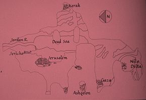
Description: In 1896 Kleopas Koikylides visited a sixth-century church
then being rebuilt in Madaba, Jordan. He discovered in the floor the oldest
extant map of Palestine, the Madaba Mosaic. It is the most significant example
of the biblical school of mapmaking to have survived and probably descends
from the lost map of Eusebius, the bishop of Caesarea. Koikylides, the librarian
for the Greek Orthodox Patriarchate in Jerusalem, halted the construction,
which tragically had damaged the mosaic, and drew scholarly attention to
this unique and splendid artifact.
The surviving sections depict biblical Palestine from Salem, south of Bet
She' an, to the Nile Delta. The map is oriented with east at the top,
and the Mediterranean coastline runs straight from left to right, aligning
Alexandria with the Holy Land coast and tracing the Nile east to west. A
study of the source material and three fragments elsewhere in the floor
indicates that originally the map measured nearly seven by twenty-two meters,
plus a wide margin, and depicted the area from Byblus and Damascus in the
north to Alexandria and the Red Sea in the south.
The biblical focus of the map is immediately apparent, though the mapmaker
carefully locates ancient sites within a contemporary framework of the local
Roman roads. The regions of five of the Twelve Tribes of Israel are distinguished
in the existing sections. There are numerous sites associated with the Old
Testament, such as the Oaks of Mamre, Jacob's Well, the Desert of Zin
that figured in the Exodus, and the location of the brazen serpent,
which saved the Israelites. New Testament features include the garden of
Gethsemane and Beth Abara, where St. John was baptized.
Much of the map depicts nonbiblical information. The Nile Delta contains
many cities. Specifically Roman references include several mileposts outside
of Jerusalem and the Hot Springs of Callerhoe, where Herod, the Roman King
of Palestine, took a rest cure. There are also two local ferries crossing
the Jordan River.
Natural features include the Jordan River, the Dead Sea, three portions
of the Mediterranean coastline, the Nile Delta, and a number of mountain
ranges. The twin mountains of Gerizein and Gegal are shown twice in different
locations in deference to both Jewish and Samaritan traditions. Palm trees
line the Jordan, and fish swim in the Jordan and the Nile. Two fishing boats
sail on the Dead Sea.
Jerusalem is dominant among the nearly 150 places described. It occupies
the center and is shown in intricate detail, nearly ten times larger than
other parts of the map. Virtually all the buildings in the city, such as
the Church of the Holy Sepulcher, may be identified. Individual gates are
designated as well as a column thought to be the point of reference for
Roman surveyors and road builders.
The excellent detail of Jerusalem allows scholars to date the map between
A.D. 560 and 565. The Church of the Theodokos was consecrated on November
23, 542, and the Wall built by Eudocia to enclose Mt. Sion was completed
shortly afterwards, in the middle of the sixth century. Accounts of Jerusalem
from about 570 begin to record alterations not depicted on the map.
According to one of the mosaics inscriptions, construction was sponsored
entirely by the inhabitants of Madaba. The project required at least three
mosaicists as well as a specialist in biblical topography. The artist chose
from a wide selection of cubes: eight different colors were used, as well
as ten additional shades of red and blue. Given the size of the original
map, nearly 2,300,000 cubes were laid. If an expert worker could place two
hundred cubes an hour, a team of three would have had to work twelve hours
a day for a full year to accomplish the design in stone.
The procedure involved composing a sketch map, drawing the outlines in wet
cement, and then placing lines of black cubes; the interior was filled in
next with colored cubes. In the mountainous areas, the hills were drawn
first, then captions, and finally the symbols for villages and churches.
In the plains the order was reversed, and the placement of symbols preceded
the inscriptions.
The map was damaged, probably during the Iconoclastic controversy in the
eighth or ninth century. The Iconoclasts, followers of the Byzantine emperors,
believed that it was idolatrous to portray living figures in churches. They
effaced scenes of a lion chasing a gazelle in the wilderness of Moab, and
sailors rowing two boats on the Dead Sea.
Damage was repaired by filling in the obliterated spaces with a random assortment
of cubes. Unfortunately, the map suffered again while the church was being
rebuilt in the nineteenth century, and these portions have been replaced
by brown and tan cement. Otherwise, the Madaba map has been preserved as
it was constructed over fourteen hundred years ago.
The two main sources for information on the map are Eusebius's Onomastikon
(388) and a Roman road map. Copies of the Onomastikon were probably
in Madaba from a very early date. Madaba was also the seat of a bishop and,
after the Council of Chalcedon in 451. Madaba and Caesarea, where Euscbius
had been bishop over a century earlier, were both under the jurisdiction
of the Patriarchate of Jerusalem. More importantly, most of the inscriptions
and place names are identical with the unique surviving Greek manuscript
of Eusebius s text.
Jerome's version of Eusebius' map, known from a twelfth century copy, bears
some similarities to the Madaba Mosaic, particularly in the rectangular
format and treatment of the Nile Delta and Mediterranean Sea. Both show
a huge inlet, called on Jerome's map the Egyptian Sea, between Palestine
and the Nile Delta (also visible on medieval maps like the Hereford World
Map of about 1275, Slide #226). The Madaba Mosaic,
however, probably reflects the lost map of Eusebius more accurately than
Jerome's does. In addition to the close textual relationship, the mosaic
is divided by the territories of the Twelve Tribes of Israel, distinguishing
feature of Eusebius s map.
The second major source is a Roman road map, similar to the Peutinger
Table (Slide #120). Madaba was on a Roman road
that linked Damascus, Philadelphia (Amman), and Petra with Aela
(Eilat). on the Gulf of Aqaba and that brought incense and spice caravans
from the East to the Roman Empire. All the cities on the mosaic lie along
major routes; lesser towns near roads are depicted to the exclusion of larger
but more remote places. Some villages are located on a road from which they
were actually far removed. Finally, a column is shown in Jerusalem that
was the point of reference for local surveyors, and two mileposts are identified
just outside the city.
The Madaba Mosaic is spectacular proof of Roman and Byzantine accomplishment.
It illustrates the scholarly work of Eusebius and the technical capabilities
of provincial mapmakers and mosaicists. No other map of Palestine is as
old, and few so masterfully portray biblical topography.
Location: Madaba, Jordan
References:
*Avi Yonah, Madaba Mosaic Map
Beazley, C. R., The Dawn of Modern Geography, volume 2, pp. 580-83, 633-36
*Nebenzahl, K., Maps of the Holy Land, pp. 24-25, Plate 5.