|
LOREN W. CROW |
CERTIFIED CONSULTING METEOROLOGIST |
Phone (303) 722-8665 or 756-3971 2422 South Downing Street Denver, Colorado 80210 April 1, 1968 |
The following is a summary of weather conditions surrounding UFO visual sightings and coincident radar echoes near Washington, D.C. and Norfolk, Virginia on the nights of July 19-20, 1952, and July 26-27, 1952.
SOURCES OF DATA
Radiosonde and wind data from -
Washington, D.C., Norfolk, Virginia, and Richmond, VirginiaSurface weather observations surrounding the times of sightings from -
Washington National Airport
Bolling AFB
Andrews AFB
Norfolk, Virginia
Newport News, Virginia
Langley AFB
GENERAL WEATHER SITUATION
The general weather situation during both nights was "hot and muggy." Maxima temperatures of the previous day, the minima and maxima on the following day were:
| 19th | 20th | 26th | 27th | ||||
| max. | min. - max. | max. | min. - max. | ||||
| WASHINGTON | 93° | 76° | 90° | 90° | 75° | 94° | |
| NORFOLK | 98° | 78° | 95° | 89° | 72° | 98° | |
On the night of the 19-20 a large, flat high-pressure area of 1020 millibars was located over the Middle Mississippi Valley and a very minor trough existed off the east coast. There were no fronts in the immediate
area of either Washington or Norfolk. The general flow of air was from west to east.
On the night of the 26-27, both Washington and Norfolk were near the center of a flat high-pressure wedge extending from Texas to several hundred miles east of New York City. A light drift from south to north characterized the air flow outward from the central portion of the wedge. Again, there were no fronts in the immediate area of either station.
THE INCIDENCE OF SCATTERED CLOUDS
It would have been possible for observers on the ground to have seen small clouds at both low and middle heights at various times during each of the two nights. Some cloud cover - mostly scattered clouds - was recorded by nearly all the observing stations where trained observers were on duty. A summary of cloud cover conditions is as follows:
| a. |
At Washington on the night of July 19-20.
At 9:30 P.M. the observer mentioned a few altocumulus at 8,000 feet. These altocumulus were not mentioned in subsequent reports until 0454 A.M. on the morning of the 20th when again in the remarks column a few altocumulus were mentioned. The hourly summary indicates a height of these clouds observed near sunrise at 18,000 feet and movement of the cloud from the northwest. The observer at Bolling AFB, just across the river from Washington National Airport, recorded various quantities of middle cloud estimated at 12,000 and 15,000 feet during the early part of the night before 10:30 P.M. No such clouds were reported between 10:30 P.M. and 3:30 A.M. At 4:30 A.M. the observer on duty at Bolling AFB reported scattered clouds at 14,000 feet and a few cumulus clouds at 5,000 feet. Observers at both Washington National Airport and Bolling AFB reported various amounts of cirrus clouds at 25,000 feet. No low or middle clouds were being reported during the darker portion of the night. It is not uncommon that observations made by trained observers during brief trips outdoors from a lighted room to view a darkened sky fail to report scattered cloud conditions. Another observer who has remained outside long enough for his eyes to adjust to darkened conditions can often see some scattered clouds. Conditions of cloudiness on this night would let some scattered clouds form and dissipate in a reasonably short period of time in any one portion of the sky. There may have been a few clouds visible to ground observers in the Washington area although they were not being reported by the official observing stations. Both the 19-20 and 26-27 nights occurred during the darker portion of the month since a full moon in July, 1952, occurred on July 7. |
|
At Norfolk on the night of July 19-20.
The scattered conditions at 4,000 feet and varying quantities of cloud at approximately 12,000 feet would have made it possible for a few scattered clouds to have been seen on an intermittent basis at various times during the night. |
|
| b. |
At Washington the night of July 26-27.
Clear conditions prevailed throughout most of the night but when daylight began to arrive between 4:00 and 5:00 A.MO, cloudiness was reported as a few stratocumulus at 2,000 feet and some thin scattered cirrus at 25,000 feet, It would have been possible for some clouds to have been visible in the area during the darker portion of the night if an observer permitted his eyes to adjust to the darkness. At Norfolk the night of July 26-27. The cloud conditions in the Norfolk area varied considerably between the Norfolk Municipal Airport and the observations made at Langley AFB several miles north of there. Langley reported clear conditions while broken or overcast cloudiness was being reported near 5,000 feet at the Norfolk Municipal Airport. There would have been a marginal area of dissipating cloud cover somewhere between Norfolk Municipal Airport and Langley AFB. Thus, multiple observers could have had a wide variety of possible cloud sightings. |
TEMPERATURE, MOISTURE AND WIND PROFILES
The conditions of the atmosphere were capable of generating anomalous propagation on weather radar displays on both nights. In Battan's book on RADAR METEOROLOGY, published in 1959, page 21, is found the following:
"Nocturnal radiation, which occurs on clear nights, especially in the summer when the ground is moist, leads to a temperature inversion at the ground and a sharp decrease in moisture with height. It is found that these conditions frequently produce abnormal propagation, which becomes more pronounced as the temperature and humidity lapse rates become larger ... These conditions which favor ducts at the ground occur most frequently over large land areas in the summer and can be thought of as situations of "radiative superrefraction."
More recent studies of anomalous propagation on radar have been made at Texas A & M. They have further confirmed the appearance of radar echoes during night and early morning hours under clear sky conditions when low level inversions and fluctuating quantities of moisture characterize the surrounding atmosphere.
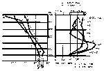
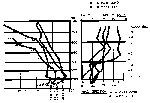
In Figures 1-4, profiles of temperature and dew point, plus wind direction and velocity, are presented. In most instances the vertical profiles near the ground would have had several degrees variation in and around each of the two stations where the radars were located. Using surface temperatures at the several airports and the actual radar sights, there would have been variations of from 3-5°F. in the first few hundred feet. Relatively small change in the vertical profiles would have occurred during the night at elevations greater than 2,500 feet. Respective percentages of relative humidity are recorded next to the moisture profile. The dashed lines report observations made at 10:00 P.M. The solid lines report values at 10:00 A.M. the following morning. The profiles would have changed gradually during the night-time hours but would have remained somewhere between these two soundings, The greatest variability in the local area would have been in the lowest few hundred feet. Near the surface, indications for 4:00 A.M. were made from surface observations.
Of some importance is the fact that rain showers were reported in the Washington area during late afternoon on the 19th of July. Amounts reported at the three stations in the Washington area ranged from .10 through .13. This would have wet the ground and furnished a variable moisture source in different portions of the surrounding countryside.
SUMMARY
It is the author's opinion that hot, humid air prevailed on both nights in both Washington and Norfolk. The general weather would have been considered fair weather by the trained observers at the various airports and they may not have reported all the scattered clouds which actually existed. It would have been considered an "easy shift." Visibilities remained above six miles at all times. The horizontal movement of scattered clouds, plus formation and dissipation of some few low clouds, both could have been seen at various times by ground observers whose eyes were well adjusted to the darkened sky. Anomalous propagation could have been observed on weather radar units during both nights at both locations. The echoes due to anomalous propagation would have had horizontal motion similar to the clouds.
LOREN W. CROW
Certified Consulting Meteorologist

|

|

|

|