|
LOREN W. CROW |
CERTIFIED
|
2422 South Downinq Street Denver, Colorado 80210 |
The following is a summary of weather conditions to determine whether or not the atmosphere was favorable to producing optical mirages and anomalous radar propagation for an area from 50 miles east of Dallas to Mineral Wells, Texas, during the time period from 2:00 A.M. to 3:00 A.M., Central Standard Time, September 19, 1957, for an aircraft flying in that region at elevations between 10,000 to 30,000 feet.
| Radiosonde and wind data from - | ||
| Carswell AFB at Fort Worth | ||
| Surface weather observations surrounding the time of UFO sightings from - | ||
| Love Field - Dallas, Naval Air Station - Dallas, Carter Field - Fort Worth, Mineral Wells, Tyler, College Station, Perrin AFB, Connolly AFB, Gray AFB. | ||
| A special study - | ||
| "On the Effects of Atmospheric Refraction on Radar Ground Patterns" by the Department of Oceonography and Meteorology, Texas A & M University, 1963. | ||
| National Bureau of Standards Monograph 92 - | ||
| "Radio Meteorology", U.S. Department of Commerce, 1966. | ||
The weather which prevailed in the entire northeast part of Texas during the early morning hours of September 19, 1957, consisted of a stable air mass with clear conditions. Air movement near the surface was from the
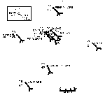
southeast at all stations. Table I on the following page presents the actual condition for ceiling, visibility, temperature, dew point, wind direction and velocity at the surface for several surrounding stations. Figure 1 presents the conditions at 2:00 A.M. for these same stations and is representative of conditions that continued beyond 3:00 A,M.
VERTICAL PROFILE OF TEMPERATURE, HUMIDITY AND WIND
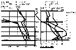
The vertical soundings of the atmosphere made about three hours before the two sightings and an equal time following gives the vertical profile of atmospheric conditions in the immediate vicinity of the sightings. The radiosondes were released at 11:30 P.M. and 5:30 A.M. respectively from Carswell AFB which is near Fort Worth, Texas.
Probably the most significant portion of the profile is the very rapid decrease in moisture content at a level between 6000 feet and 7000 feet. Temperatures increased with height in this same layer. Beneath this inversion layer the wind direction changed from southerly in the lower part of the atmosphere to a westerly and northerly direction at approximately 6000 feet. Wind velocities increased during the night in the layer between 2000 feet and 5000 feet. Figure 2 presents this pattern for the two different soundings.
EFFECTS OF TEMPERATURE AND HUMIDITY ON REFRACTIVE INDEX
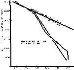
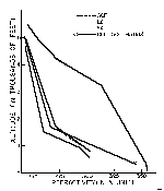
If a radio ray (including radar) is propagated in free space, where there is no atmosphere, the path followed by the ray is a straight line. However, a ray that is propagated through the earth’s atmosphere encounters variations in the atmospheric refractive index along its trajectory that caused the ray path to become curved. The total angular refraction of the ray path between two points is couunonly called the "bending" of the ray. This "bending" is strongly influenced by rapid changes in refractive index within the atmosphere and such rapid changing in refractive index is caused by rapid changes in the moisture in the air. The typical temperature inversion permits the temperature to increase over a farily short increase in height, while at the same time the amount of moisture decreases rapidly. Experimental work has developed relationships between the moisture content and the refractive index so that data obtained in the vertical sounding of temperature and humidity from a radiosonde can be converted to corresponding values of refractive index. Figure 3 presents the profile of refractive index that directly corresponds with the vertical temperature and humidity profile in Figure 2.
In Figure 3 a critical gradient line is drawn for change in refractive index with height. Later discussion will indicate the importance of this critical gradient.
STANDARD ATMOSPHERE VERSUS ACTUAL ATMOSPHERE
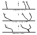
When only a standard atmosphere is considered the change in temperature and humidity with height is quite gradual and there are no sharp changes due to rapid decreases in humidity. Figure 4 gives the typical profiles for a standard atmospheric profile in the top part of the figure. The
|
|
||||||
| Ceiling | Visibility | Temperature | Dew Point | Wind Direction & Velocity |
||
| Perrin AFB | clear | 15 miles | 72 ° F | 66 ° F | SE 9 | |
| Mineral Wells | clear | 25 | 72 | 66 | SE 9 | |
| Ft. Worth | clear | 15+ | 72 | 66 | SE 10 | |
| Naval Air Station | clear | 15 | 75 | 69 | SE 16 | |
| Love Field-Dallas | clear | 15 | 74 | 68 | SE 10 | |
| Tyler | clear | 12 | 70 | 67 | SE 5 | |
| Connally AFB | clear | 15 | 73 | 67 | SSE 3 | |
| Gray AFB | clear | 15 | 73 | 67 | SE 4 | |
|
|
||||||
|
|
||||||
| Perrin AFB | clear | 15 | 71 | 66 | SE 9 | |
| Mineral Wells | clear | 25 | 71 | 66 | SE 10 | |
| Ft. Worth | clear | 15+ | 72 | 67 | SE 9 | |
| Naval Air Station | clear | 15 | 75 | 69 | SE 14 | |
| Love Field-Dallas | clear | 15 | 73 | 67 | SE 10 | |
| Tyler | clear | 12 | 70 | 66 | SE 5 | |
| Connally AFB | clear | 15 | 72 | 67 | SSE 3 | |
| Gray AFB | clear | 15 | 72 | 64 | SSE 6 | |

|
|
|
|
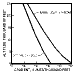
middle portion and the lower portion of Figure 4 indicate the corresponding effect on the change in refractive index with height as inversions are observed near the surface and at some elevated layer. In both of the non-standard patterns the gradient of N is somewhat greater than the critical value capable of producing ducting of microwave energy.
Of special importance in this investigation was some research work done at Texas A & M using their 3.2-Cm. AN/CPS-9 weather radar. The report, prepared by L. B. Cobb and V. E. Moyer, covers research carried out in 1962 and 1963, supported by National Science Foundation Grant NSF G-13834. This study was particularly interested in abnormal PPI presentations of radar echoes that occurred during clear weather.
The effect of atmospheric refraction on microwave propagation in the lower troposphere is a problem with which radio engineers and radio meteorologists have been vitally concerned since World War II. Prior to that time, thespeed of propagation of electromagnetic energy had been considered to be a constant, that of the speed of light in a vacuum. As radar, missiles, and other radio-controlled equipment were developed and became more complex, evidence of small changes in the speed of propagation due to atmospheric conditions began to mount. These small changes in speed are very important as they cause refraction, or a change in the direction of propagation, of the electromagnetic energy. Radar trapping, errors in the positioning of targets, the radio hole, fading of radio signals, and "anomalous" echoes on weather radar scopes are some of the problems encountered, Any observer who makes critical deductions based on radar observations may be tricked into bad decidions unless he is familiar with the limitations of the equipment under nonstandard atmospheric conditions. Radar echoes of unknown origin near a vertical beam above the earth’s surface are commonly called "angels". Unusual echoes from the surface are generally referred to as "anomalous propagation" or "AP". Both of these phenomena have been aucribed to abnormal refraction of the radio ray,
A study of abnormal radar echoes made at Texas A & M dealt primarily with anomalous propagation brought about by ducting or bending of radar beams due to inversions near the surface, They studied the expansion of ground clutter echoes due to increased gradient of refractive index near the surface. They examined large areas of anomalous echoes separated from the normal ground clutter pattern brought about by both strong surface inversions and strong upper level inversions.
The index of refraction, n, of electromagnetic energy in a non-dispersive medium such as the troposphere is defined as the ratio of the speed of propagation in a vacuum to the speed of propagation in the medium:
|
(1) |
The speed of radar energy in the atmosphere is slightly less than the speed in a vacuum, so that the index of refraction always is very close to, but in excess of, unity. A typical example is 1.000287. For con- vience in handling, the index of refraction is converted to a
"refractive modulus," N, which is referred to most frequently as "refractivity":
|
(2) |
The refractivity for the above example would be 287.
The index of refraction is a function of temperature, pressure, and humidity, their relationship being given by the equation
|
(3) |
where p is the total atmospheric pressure in millibars, e is the partial pressure of atmospheric water vapor in millibars, T is the temperature in degrees Kelvin, and the constants A (= 76.6 deg/mb)* and B (= 4810 deg)* are average values recommended by Smith and Weintraub. A is the dielectric constant for dry air and B is the water vapor dipole moment. The formula is correct to within 0.5 per cent for the temperature range of -50C to 40C and the frequency range of 30 mc/sec to 30 kmc/sec. The actual amount of refraction is small, never exceeding a fraction of a degree; it is usually expressed in milliradians, or "mils." Therefore, radar operations will be influenced most when the angle between the refracting layer and the radar ray is very small.
Standard propagation occurs when the atmosphere is stratified vertically in such a way that a lapse of 12 N-units occurs in each 1000 ft. Under these conditions, a horizontal radar ray will be bent downward slightly due to increasing velocity aloft. This increase in velocity is very small; e.g., in the time it takes the horizontal ray to travel 1 mi at the surface, it will travel 1 mi. plus 3/4 in. at a height 1000 ft above the surface. This has the effect of extending the radar horizon about 15 per cent beyond the geometric horizon,
Nonstandard propagation will result when the temperature or water content of the atmosphere vary significantly from so-called ‘standard" values. Substandard refraction, i.e., less downward bending or possible aztual upward bending of the radar ray, will occur if the refractivity is constant or increases with height. The propagation is superstandard if the refractivity decreases with height at a rate exceeding the standard rate. This causes an increased downward bending of the ray. If the velocity difference between the surface and 1000 ft achieves 3in./mi of horizontal travel, as occurs with a refractivity of -48N/l000 ft., a ray will have the same curvature as the earth with resultant greatly extended horizons, a condition referred to as "ducting." Superrefraction normally results from a combination of increasing temperatures and decreasing humidities with height. Nocturnal radiational cooling at the surface and normal lack of nighttime convection will cause a temperature inversion, if other physical parameters are favorable, These
conditions are conducive to the formation of superrefractive strata in the lower troposphere. The formation of superrefractive strata is favored by clear skies and low wind speeds.
Elevated superrefractive layers also occur with temperature inversions or in stable layers in which there is a decrease in moisture with height. Subsidence inversions are the most common cause of this situation.
LOCAL TERRAIN SURROUNDING COLLEGE STATION, TEXAS
When the beam of a radar unit is used to cover a large horizontal area - from 200 to 300 miles - the elevation angle of the beam must be at or near zero. Near the radar site, even when the antenna is several feet above the around, part of the energy is “echoed” back from nearby objects and/or the ground itself. As the energy goes farther and farther from the radar site the curvature of the earth permits the beam to extend into the air mass higher and higher above the earth’s surface. The local terrain surrounding any particular radar location helps define the tpyical ground pattern. Figure 5 shows the topographic map of area within 150 miles of College Station, Texas.
A standard pattern must be determined if one wishes to ascertain the degree of abnormality of nonstandard patterns. Figure 6 presents the PPI (Plan Position Indicator) pattern for College Station with the elevation angle set at 00 and a full gain setting of the receiver. It is the ground return pattern associated with standard refraction in the atmosphere. The black circle shown in Figure 6 encloses an area inside 25 miles from the radar site at College Station (CCL). The terrain features in Figure 5 are reflected in this normal ground pattern. For example, the line of echoes oriented southwest - northeast (approximately 25 miles south of OLL) represents the ridge which rises south of Yegua Creek west of Navasota. The low ground along the three streams - Brazos River, Yegua Creek, Navasota River - is indicated by the converging blue lines which join to form the expanded Brazos River near Navasota before it heads southeastward to empty into the Gulf at Freeport.
Figure 6 can be reproduced with a 00 beam angle and a near standard atmosphere day after day at College Station, Texas, and can be considered the normal ground pattern. A standard pattern must be determined if one wishes to ascertain the degree of abnormality of nonstandard patterns.
EXPANSION OF NORMAL GROUND PATTERN
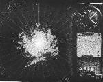
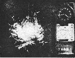
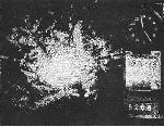
Eleven cases were studied in which anomalous propagation caused an expansion of the normal ground pattern. The amount of additional echo observed varies from scattered, small additions to large areas of anomalous echoes which extend beyond the 50 mi range. The eleven cases were divided roughly according to whether they had small or large amounts of AP. Examples from each division are shown in Figures 7 and 8. The black circles enclose the same 25 mile radius area in these figures as in Figure 6.

|
|
|
|
The conmion feature of all cases was a surface refracting layer less than 2000 ft thick, overlain by air of standard or near-standard refraction. The difference in refractivity between the two divisions is reflected in the extent to which the ground pattern is expanded. The smaller expansions of AP echoes are associated with smaller refractivity values, and larger amounts with larger values. All cases with greater amounts of AP were from periods of higher temperatures than those with lesser amounts. Warmer air masses, with their larger values of temperature and humidity, have greater values of refractivity. However, the gradient of N, rather than the discrete values of N, is most important in determining the refracting properties of an air mass.
The difference in amount of anomalous echoes appear to depend upon the gradient and thickness of the surface refracting layer. All of the smaller amounts occurred with gradients between 18N/lO0O ft and 30N/lOO0 ft; the larger amounts occurred with gradients between 26N/l000 ft and 40N/lOOO ft. In general, the refracting layer was thicker when the larger amounts of anomalous echoes were observed. However, the thickness of the surface refracting layer was less than 1600 ft in all cases.
The anomalous echoes are related to the topographic features. Comparison of Figure 7 with a map of the terrain shows that the excess echoes (indicated by white arrows) are reflections from hills at those locations. These hills are not detected under standard refractive conditions, but are detected when the radar ray is bent one and one-half to two times the standard rate of bending. Greater bending of the ray will cause additional topographic features to be presented on the PPI (Figure 8).
LARGE AREAS OF ECHO SEPARATED FROM THE NORMAL GROUND PATTERN
The examples that are included in this group are those which have anomalous echoes at a considerable distance from the normal ground pattern. In some cases, these echoes encircle the local area; in others, they are confined to one or two quadrants. In most cases, they appear to be caused by an elevated ducting layer.
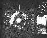
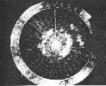
Two examples of anomalous echoes which encircle the local area are considered first. Figures 9 and 10 are examples of "radial patterns" which occurred on 7 May 1962 and 12 February 1962. The black circles again chow an area of 25 miles radius nearest OLL. A polaroid photograph is presented for 7 May because the regular photographs were not useable. In the case of 12 February, there had been a complete ring of echoes earlier, but those in the eastern quadrants had begun to disappear by 0820C5T, when the photograph was taken. The refractivity profiles for both dates were very similar.
A large anticyclone was located over the Gulf of Mexico at the surface, with a smaller high-pressure area aloft centered over Texas, on both 7 May 1962 and 12 February 1962. Thus, there was a layer of moist Gulf air near the surface, overlain by a very dry layer caused by subsidence. Nocturnal radiational cooling at the surface, together with the subsidence warming aloft, created a very sharp inversion. These are the ideal conditions for the formation of an elevated superrefractive layer, with
|
|
There are several characteristics which distinguish these echoes from those discussed previously. First, a radial pattern is caused by total or near-total refraction from an elevated layer, so that its location is dependent on the vertical distance between the radar and the layer, as well as on the antenna elevation angle. Terrain features are of secondary importance in giving the pattern its shape and location. Second, these echoes usually persist longer because it takes much more convective mixing to destroy an elevated layer than is needed to destroy a layer next to tite surface. Third, elements of a second ring of echoes are often observed; they probably result from a second ‘bounce" of the ray between the surface and the refracting layer.
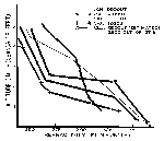
A good example of anomalous echoes associated with the formation of an elevated refracting layer occurred during the night of 27 April 1962. An elongated low-pressure trough aloft, extending from Illinois to central Texas, triggered severe thunderstorms as it moved eastward during the day, Clearing occurred over the southern half of the state during the afternoon, but thunderstorms continued in the Dallas-Shreveport area. Moist Gulf air was flowing northward aloft, ahead of the trough, at the time of the 0000UT radiosonde soundings; it was replaced by very dry air from the west after passage of the trough. Figure 11 shows the refractivity profiles for San Antonio (SAT) and Lake Charles (LCII) at 0000 Universal Time (UT) and 1200UT, 28 April (1800CST, 27 April and O600CST; 28 April); the profile for Ft. Worth (ACF) is not shown as it did not change appreciably from one sounding to the next. The formation of an elevated superrefractive layer is clearly indicated at both stations between the times of the two soundings. Figure 12 shows the AP echoes which had formed in the southern quadrants by 2250CST (skies were then clear); the echoes to the north were caused by thunderstorms.
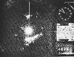
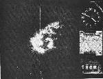
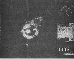
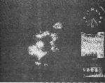
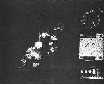
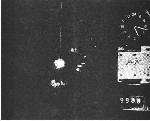
The last example to be considered:.in this group occurrad on 9 February 1962 (Figure l3a-e). Skies were generally clear over the state, except for some early morning fog along the coast and low stratus clouds which dissipated as the temperature increased. A large high-pressure area was situated over the southeastern United States, so that warm, moist air was flowing northward from the Gulf at the lower levels. Cold, dry air aloft had entered Texas from the northwest; the 1200UT refractivity profiles (Figure 14) indicate that this air had not reached LCH. Very strong superrefractive layers existed at ACF and SAT; it appears to be a reasonable assumption that such a layer existed at CLL also, if one considers the amount of anomalous echoes that were occurring (Figure 13a-e). Both the profiles and the photographs demonstrate that the pattern was not a true radial pattern at 0850CST, although echoes occurred in all directions. During the next 15 min, heating and convective mixing began to destroy
|
|
|
|
|
|
|
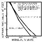
In Chapter 13 of the Handbook of Geophysics for Air Force Designers, published by the U. S. Air Force in 1957, various equations, tables, and nomograms are presented covering electromagnetic wave propagation in the lower atmosphere. Figures 15 and 16, as copied from that book, show how refractive modulus values vary with altitude for both optical and radio wavelengths. As shown in Figure 16 the two curves for optical and radio wavelengths converge at altitudes greater than 20,000 feet. This would indicate that any abnormal ducting of optical and/or radar type images might be similarly distorted to observers in aircraft flying above 20,000 feet when atmospheric abnormalities are uniquely favorable for anomalous propagation.
AIRCRAFT PENETRATION OF CLEAR AIR "ANGELS"
At the Ninth Weather Radar Conference in Kansas City in 1961, R. Q. Tillman, R. E. Ruskin, and M. N. Robinson of the U. S. Naval Research Laboratory, reported on the tracking of approximately 500 clear air "angel" echoes. Most of the "angels plotted had radar cross sections between approximately 0.2 and 3 cm 2
The maximum detectable range usually fell between 2,000 and 4,000 yards. On occasion, distinct angels with the appearance and characteristics of large airplanes or vessels were tracked, presenting targets roughly 100 times the minimum detectable target at that range. The physical extent of most of the angels, as deduced from manually varying the range setting across the target, was approximately 35 yards.
A series of attempts was made to vector an instrumented WV-2 SuperConstellation aircraft through. the apparent location of the angel echoes. Of 28 attempts, 4 were successful. The plane was directed hy radio by the radar operators, using the altitude and beading information from the plotting boards. On the four successful runs the plane passed directly through the telescope cross hairs, and its radar return was visible in the range notch of the A-scopes. In each case the radar shifted to this stronger target. However, in one run it was possible to unlock momentarily from the plane and to pick up the angel again. On another occasion, the angel echo disappeared when the aircraft passed through. The aircraft instrumentation included: a rapid-response refractometer, a vortex thermometer, electric field and conductivity instruments, and space charge detector. In none of the four instances was there any correlation between
|
Cloudless skies and good visibility prevailed at the time of the UFO sightings in an area from 50 miles east of Dallas to Mineral Wells, Texas in the eatly morning hours of September 19, 1957. Therefore, the UFO sightings were not related to cloudiness, lightning, or radar echoes from shower activity near the flight path.
The vertical profile of tile atmosphere as measured at Ft. Worth did contain a sharp temperature inversion near the 6000 - 7000 foot level (Figure 2). The temperature increased and moisture content decreased rapidly with height in this layer. The change with height was great enough to permit a corresponding gradient of refractive index near the criticJ level which allows extensive anomalous propagation of either optical or radar energy (see Figures 3 and 16). The aircraft crew, although flying above the ducting layer, could have been receiving echoes and/or images of objects or lights many miles from the path of the aircraft. The ground operators of radar, located below the ducting layer, probably were observing echoes which were part of an anomalous propagation pattern transmitted to them due to the elevated refracting layer.
The air mass itself would have been changing slowly with respect to time during the night time hours. From a fixed position the ground radar operators would have been able to detect anomalous propagation near one particular position for fairly long periods. By contrast the airborne equipment would have been constantly changing its position relative to both the surrounding atmosphere and terrain. The probable ducting of images from considerable distances through the layered atmosphere would have tended to keep the images in the same general direction from the aircraft and at some distance away from the aircraft itself. This is in some ways similar to the observation of a rainbow from a moving automobile.
It is worthy to note that a large fraction of the reports on detailed research which have been used as references for the conclusions in this study have publication dates after September 1957. Even in 1968 it is not likely that the results of such research are common knowledge to a high fraction of aircraft crews who might on rare occasions fly near a "ducting layer" which is invisible in a cloudless atmosphere.
The detailed observations are being retained in my files. Should they be of further use to you please let me know.
LWC :dd
|
|